
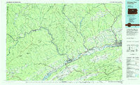
~ Williamsport West PA topo map, 1:100000 scale, 30 X 60 Minute, Historical, 1984, updated 1985
Williamsport West, Pennsylvania, USGS topographic map dated 1984.
Includes geographic coordinates (latitude and longitude). This topographic map is suitable for hiking, camping, and exploring, or framing it as a wall map.
Printed on-demand using high resolution imagery, on heavy weight and acid free paper, or alternatively on a variety of synthetic materials.
Topos available on paper, Waterproof, Poly, or Tyvek. Usually shipping rolled, unless combined with other folded maps in one order.
- Product Number: USGS-5332008
- Free digital map download (high-resolution, GeoPDF): Williamsport West, Pennsylvania (file size: 18 MB)
- Map Size: please refer to the dimensions of the GeoPDF map above
- Weight (paper map): ca. 55 grams
- Map Type: POD USGS Topographic Map
- Map Series: HTMC
- Map Verison: Historical
- Cell ID: 68595
- Scan ID: 223672
- Imprint Year: 1985
- Woodland Tint: Yes
- Aerial Photo Year: 1980
- Edit Year: 1984
- Datum: NAD27
- Map Projection: Universal Transverse Mercator
- Planimetric: Yes
- Map published by United States Geological Survey
- Map Language: English
- Scanner Resolution: 600 dpi
- Map Cell Name: Williamsport West
- Grid size: 30 X 60 Minute
- Date on map: 1984
- Map Scale: 1:100000
- Geographical region: Pennsylvania, United States
Neighboring Maps:
All neighboring USGS topo maps are available for sale online at a variety of scales.
Spatial coverage:
Topo map Williamsport West, Pennsylvania, covers the geographical area associated the following places:
- Big Run - Grimesville - Collomsville - Leidy - Parvin - Rote - Gillintown - Quiggleville - Bluestone - Woolrich - Balls Mills - Dunnstown - East Ferney - Chatham Run - Pancake - Hepburn Heights - Castanea - Woodland Park - Crestmont - Whetham - Monument - Elimsport - Queens Run - Newberry - Avis - Antes Fort - Lockport - Buttonwood - Westport - Rhoads - Blanchard - Rauchtown - Hilborn - Gallagher - Powys - Fountain - Williamsport - Lamar - Eagleton Fields - Heshbon Park - Nippono Park (historical) - English Mills - Castle Rocks - Torbert - North Bend - Caldwell - McElhattan - Carroll - English Center - Orviston - Lock Haven - Drury Run - Hammersley Fork - Greenburr - Beech Creek - Renovo - Twin Hollows - Salona - Eagleville - Pine Run - Cammal - Hyner View - Mackeyville - Keating - Hepburnville - Jersey Mills - Pine - Mill Hall - Duboistown - Clintondale - French Settlement - Flemington - Gleasonton - Steam Valley - Garden View - Nisbet - Gray - Shakespeare Club - West Hills Estates - Lucullus - Level Corner - Haneyville - Draketown - Birch - Lebo Vista - Swissdale - Shintown - Salladasburg - Beulah Land - Charlton - Loganton - Tamarack - Farwell - East Hill - Rosecrans - Cedar Springs - Ferney - Ritchie - Romola - Haleeka
- Map Area ID: AREA41.541-78-77
- Northwest corner Lat/Long code: USGSNW41.5-78
- Northeast corner Lat/Long code: USGSNE41.5-77
- Southwest corner Lat/Long code: USGSSW41-78
- Southeast corner Lat/Long code: USGSSE41-77
- Northern map edge Latitude: 41.5
- Southern map edge Latitude: 41
- Western map edge Longitude: -78
- Eastern map edge Longitude: -77


