
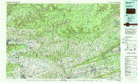
~ Williamsport East PA topo map, 1:100000 scale, 30 X 60 Minute, Historical, 1984, updated 1988
Williamsport East, Pennsylvania, USGS topographic map dated 1984.
Includes geographic coordinates (latitude and longitude). This topographic map is suitable for hiking, camping, and exploring, or framing it as a wall map.
Printed on-demand using high resolution imagery, on heavy weight and acid free paper, or alternatively on a variety of synthetic materials.
Topos available on paper, Waterproof, Poly, or Tyvek. Usually shipping rolled, unless combined with other folded maps in one order.
- Product Number: USGS-5332006
- Free digital map download (high-resolution, GeoPDF): Williamsport East, Pennsylvania (file size: 30 MB)
- Map Size: please refer to the dimensions of the GeoPDF map above
- Weight (paper map): ca. 55 grams
- Map Type: POD USGS Topographic Map
- Map Series: HTMC
- Map Verison: Historical
- Cell ID: 68594
- Scan ID: 223671
- Imprint Year: 1988
- Woodland Tint: Yes
- Aerial Photo Year: 1981
- Edit Year: 1984
- Datum: NAD27
- Map Projection: Universal Transverse Mercator
- Map published by United States Geological Survey
- Map Language: English
- Scanner Resolution: 600 dpi
- Map Cell Name: Williamsport East
- Grid size: 30 X 60 Minute
- Date on map: 1984
- Map Scale: 1:100000
- Geographical region: Pennsylvania, United States
Neighboring Maps:
All neighboring USGS topo maps are available for sale online at a variety of scales.
Spatial coverage:
Topo map Williamsport East, Pennsylvania, covers the geographical area associated the following places:
- Glen Lyon - Slocum Corners - Ripple - Jonestown - Hoppestown - Noxen - Millville - Beaver Lake - Outlet - Hess Island - Wrights View - Slocum - Light Street - Central - Ripple (historical) - Eagles Mere Park - Sweet Valley - Spring Garden - Huntersville - Martzville - Farragut - Hallwood - Ringdale - Polkville - Millertown - Watsontown - Bodines - Harveys Lake - Bloomsburg - Honeytown - Rohrsburg - Grassmere Park - Muhlenburg - Mordansville - Tri Mills - Talmer - Eyers Grove - Calvert - Lime Ridge - Broadway - Hunlock - Strawbridge - North Hills - Hunlock Gardens - Springtown - Beech Glen - Moyers Grove - East Millville - McCarroll Corner - Five Points - Nescopeck - North Mountain - Laketon - Derrs - Sereno - Ceasetown - Jackson - Hughs - Pennsdale - Bernice - Muncy Valley - Five Points - Plunkett - West Nanticoke - Bryan Mill - Weintz - Alvira (historical) - Bendertown - Biggerstown - Canyon Vista - Loyalsockville - Roaring Brook - Dorrance - Zenith - Patterson Grove - Harveyville - Milton - Idetown - Clarkstown - Columbia Hill - Cease Mills - Ritters Crossroads - Mossville - Colonial Park - Pine Summit - Warrior Run - Villa Grove - Glen Mawr - Orangeville - Long Brook - Lymehurst - Iola - Stull - Prichard - Register - Proctor - Cambra - Nordmont - Ottawa - Maple Grove
- Map Area ID: AREA41.541-77-76
- Northwest corner Lat/Long code: USGSNW41.5-77
- Northeast corner Lat/Long code: USGSNE41.5-76
- Southwest corner Lat/Long code: USGSSW41-77
- Southeast corner Lat/Long code: USGSSE41-76
- Northern map edge Latitude: 41.5
- Southern map edge Latitude: 41
- Western map edge Longitude: -77
- Eastern map edge Longitude: -76


