
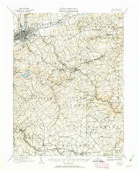
~ York PA topo map, 1:62500 scale, 15 X 15 Minute, Historical, 1908, updated 1963
York, Pennsylvania, USGS topographic map dated 1908.
Includes geographic coordinates (latitude and longitude). This topographic map is suitable for hiking, camping, and exploring, or framing it as a wall map.
Printed on-demand using high resolution imagery, on heavy weight and acid free paper, or alternatively on a variety of synthetic materials.
Topos available on paper, Waterproof, Poly, or Tyvek. Usually shipping rolled, unless combined with other folded maps in one order.
- Product Number: USGS-5331906
- Free digital map download (high-resolution, GeoPDF): York, Pennsylvania (file size: 8 MB)
- Map Size: please refer to the dimensions of the GeoPDF map above
- Weight (paper map): ca. 55 grams
- Map Type: POD USGS Topographic Map
- Map Series: HTMC
- Map Verison: Historical
- Cell ID: 64800
- Scan ID: 222622
- Imprint Year: 1963
- Survey Year: 1908
- Datum: NAD27
- Map Projection: Polyconic
- Map published by United States Geological Survey
- Map Language: English
- Scanner Resolution: 600 dpi
- Map Cell Name: York
- Grid size: 15 X 15 Minute
- Date on map: 1908
- Map Scale: 1:62500
- Geographical region: Pennsylvania, United States
Neighboring Maps:
All neighboring USGS topo maps are available for sale online at a variety of scales.
Spatial coverage:
Topo map York, Pennsylvania, covers the geographical area associated the following places:
- Strathcona Hills - Yorklyn - Kalreda Woods - Tolna - Grove Mill - Hungerford - Fireside Terrace - Snyder Corner - Hopewell Center - Yorktown Homes - Fenmore - Keys - Laurel - Crestwood East - Carol Heights - Sylvania Heights - Locust Spring - Waterford - Grantly Hills - Orchard Hill - Kendale East - Bittersville - Holtz - Farquhar Estates - Appleton - Arbor - Leaders Heights - South View Acres - Sechrist Mill - Longview Heights - Skyline Heights - Avondale - Yorkshire - Jacobus - Willis Park - Pleasureville - Fair Acres - Relay - Forest Hills - Dalvue - Sylvan Hills - Spry - Ridgefield - Hillcrest - Railroad - Hametown - Wyndham Hills - East York - Starview Heights - Anstine - Meadetown - Yoe - Valley Forge - Shrewsbury - Rinely - Stonybrook - Martinsville - South Ridge Estates - Sheffer - Leiphart Mill - York - Rye - Oakridge - Fox Run - Villa Green - Barwood - Tri-Hill - Shrewsbury Station - Grandview Heights - Longstown - Loganville - Windsor - Brownton - Penn Oaks - Oak Manor - Crestview Terrace - Springdale - McDonald Heights - Hollywood Heights - Denton Terrace - Reimold - Valley View - Southwood Hills - Rockey - Winterstown - Spring Plains - South Wood Hills - Marborough West - Ore Valley - East Yoe - Springvale - North York - Glen Rock - Wilshire Hills - Robin Heights - Greystone Farms - Orwig - Chapel View - Leafydale Terrace - McClellan Heights
- Map Area ID: AREA4039.75-76.75-76.5
- Northwest corner Lat/Long code: USGSNW40-76.75
- Northeast corner Lat/Long code: USGSNE40-76.5
- Southwest corner Lat/Long code: USGSSW39.75-76.75
- Southeast corner Lat/Long code: USGSSE39.75-76.5
- Northern map edge Latitude: 40
- Southern map edge Latitude: 39.75
- Western map edge Longitude: -76.75
- Eastern map edge Longitude: -76.5


