
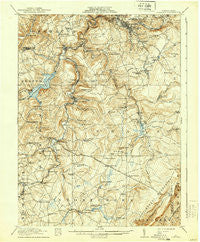
~ Windber PA topo map, 1:62500 scale, 15 X 15 Minute, Historical, 1916, updated 1939
Windber, Pennsylvania, USGS topographic map dated 1916.
Includes geographic coordinates (latitude and longitude). This topographic map is suitable for hiking, camping, and exploring, or framing it as a wall map.
Printed on-demand using high resolution imagery, on heavy weight and acid free paper, or alternatively on a variety of synthetic materials.
Topos available on paper, Waterproof, Poly, or Tyvek. Usually shipping rolled, unless combined with other folded maps in one order.
- Product Number: USGS-5331892
- Free digital map download (high-resolution, GeoPDF): Windber, Pennsylvania (file size: 9 MB)
- Map Size: please refer to the dimensions of the GeoPDF map above
- Weight (paper map): ca. 55 grams
- Map Type: POD USGS Topographic Map
- Map Series: HTMC
- Map Verison: Historical
- Cell ID: 64614
- Scan ID: 222592
- Imprint Year: 1939
- Survey Year: 1914
- Datum: Unstated
- Map Projection: Polyconic
- Map published by United States Geological Survey
- Map Language: English
- Scanner Resolution: 600 dpi
- Map Cell Name: Windber
- Grid size: 15 X 15 Minute
- Date on map: 1916
- Map Scale: 1:62500
- Geographical region: Pennsylvania, United States
Neighboring Maps:
All neighboring USGS topo maps are available for sale online at a variety of scales.
Spatial coverage:
Topo map Windber, Pennsylvania, covers the geographical area associated the following places:
- Friedens - Benson - Stoystown - Mostoller - Forward - Blough - Indian Lake - Hollsopple - Lambertsville - Hillsboro - Foustwell - Shanksville - Kimmelton - Old Shade Furnace - Maple Ridge - Hagero - Kantner - Davidsville - Scalp Level - Landstreet - Buckstown - Rowena - Ashtola - Reitz - Jerome Junction - Reading Number Three - Cairnbrook - Reels Corners - Seanor - Gahagen - Grand View - Rummel - Jerome - Paint - Coleman - Thomas Mill - Hooversville - Wells Creek - Wilbur - Central City - Boone - Windber
- Map Area ID: AREA40.2540-79-78.75
- Northwest corner Lat/Long code: USGSNW40.25-79
- Northeast corner Lat/Long code: USGSNE40.25-78.75
- Southwest corner Lat/Long code: USGSSW40-79
- Southeast corner Lat/Long code: USGSSE40-78.75
- Northern map edge Latitude: 40.25
- Southern map edge Latitude: 40
- Western map edge Longitude: -79
- Eastern map edge Longitude: -78.75


