
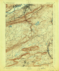
~ Wilkes Barre PA topo map, 1:62500 scale, 15 X 15 Minute, Historical, 1894, updated 1929
Wilkes Barre, Pennsylvania, USGS topographic map dated 1894.
Includes geographic coordinates (latitude and longitude). This topographic map is suitable for hiking, camping, and exploring, or framing it as a wall map.
Printed on-demand using high resolution imagery, on heavy weight and acid free paper, or alternatively on a variety of synthetic materials.
Topos available on paper, Waterproof, Poly, or Tyvek. Usually shipping rolled, unless combined with other folded maps in one order.
- Product Number: USGS-5331838
- Free digital map download (high-resolution, GeoPDF): Wilkes Barre, Pennsylvania (file size: 8 MB)
- Map Size: please refer to the dimensions of the GeoPDF map above
- Weight (paper map): ca. 55 grams
- Map Type: POD USGS Topographic Map
- Map Series: HTMC
- Map Verison: Historical
- Cell ID: 64546
- Scan ID: 170100
- Imprint Year: 1929
- Survey Year: 1891
- Datum: Unstated
- Map Projection: Polyconic
- Map published by United States Geological Survey
- Map Language: English
- Scanner Resolution: 600 dpi
- Map Cell Name: Wilkes Barre
- Grid size: 15 X 15 Minute
- Date on map: 1894
- Map Scale: 1:62500
- Geographical region: Pennsylvania, United States
Neighboring Maps:
All neighboring USGS topo maps are available for sale online at a variety of scales.
Spatial coverage:
Topo map Wilkes Barre, Pennsylvania, covers the geographical area associated the following places:
- Honey Hole - Upper Lehigh - Albert - Moosehead - Plymouth - Ochre Mill - Middleburg - Penn Lake Park - Rita - Edgewood - Laurel Run - Breslau - Glen Summit - Boulevard Manor - Avondale - Larksville - Bridgeport - Gracedale - Witinski Villa - Fairview Heights - Blytheburn - Wilkes-Barre - Kis-Lyn - Curry Hill - Youngstown - Rippletown - Warrior Run - Dundee - Plymouth Junction - Newton - Woodside - Drums - Nuangola - Preston - South Heberton - Avondale Hill - Pine View - Lee Park - Beech Mountain Lakes - Tannery - Oliver Mills - Reilly - Hanover Green - Georgetown - Ashley - Sickler Hill - Buttonwood - Mountain Top - Lynnwood - Hanover - Pond Creek - Rule Corners - Lindbergh - Franklin Junction - Pardeesville - Bear Creek Village - Lower Askam - Highlands - Fairview - Bliem Corners - Sand Spring - Llewellyn Corners - Wech Corners - Bear Creek Junction - East Side - White Haven Center - Liewellyn Corners - Askam - Sugar Notch - Johnson Greene - Nescopeck Pass - Forest Park - Korn Krest - Port Jenkins - Truesdale Terrace - Penobscot - Springtown - Solomon Gap - White Haven - Loomis Park - Hickory Hills - Rumbels - Nuangola Station - Sandy Run - Freeland
- Map Area ID: AREA41.2541-76-75.75
- Northwest corner Lat/Long code: USGSNW41.25-76
- Northeast corner Lat/Long code: USGSNE41.25-75.75
- Southwest corner Lat/Long code: USGSSW41-76
- Southeast corner Lat/Long code: USGSSE41-75.75
- Northern map edge Latitude: 41.25
- Southern map edge Latitude: 41
- Western map edge Longitude: -76
- Eastern map edge Longitude: -75.75


