
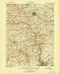
~ West Chester PA topo map, 1:62500 scale, 15 X 15 Minute, Historical, 1904, updated 1951
West Chester, Pennsylvania, USGS topographic map dated 1904.
Includes geographic coordinates (latitude and longitude). This topographic map is suitable for hiking, camping, and exploring, or framing it as a wall map.
Printed on-demand using high resolution imagery, on heavy weight and acid free paper, or alternatively on a variety of synthetic materials.
Topos available on paper, Waterproof, Poly, or Tyvek. Usually shipping rolled, unless combined with other folded maps in one order.
- Product Number: USGS-5331836
- Free digital map download (high-resolution, GeoPDF): West Chester, Pennsylvania (file size: 9 MB)
- Map Size: please refer to the dimensions of the GeoPDF map above
- Weight (paper map): ca. 55 grams
- Map Type: POD USGS Topographic Map
- Map Series: HTMC
- Map Verison: Historical
- Cell ID: 64403
- Scan ID: 222477
- Imprint Year: 1951
- Datum: Unstated
- Map Projection: Polyconic
- Map published by United States Geological Survey
- Map Language: English
- Scanner Resolution: 600 dpi
- Map Cell Name: West Chester
- Grid size: 15 X 15 Minute
- Date on map: 1904
- Map Scale: 1:62500
- Geographical region: Pennsylvania, United States
Neighboring Maps:
All neighboring USGS topo maps are available for sale online at a variety of scales.
Spatial coverage:
Topo map West Chester, Pennsylvania, covers the geographical area associated the following places:
- Chalfonte - Winterthur - Pamona Park - North Chase - Queonemysing (historical) - Chatwood - Serpentine Acres - Brandywood - Cherrington - Penarth - Holiday Hills - Stuyvesant Hills - Cossart Creek - Chadds Ford Junction - Barley Woods - York Towne - Westtown Hillside - Quintynnes - Lenape - Granogue - Sedgley Farms - Rockland Woods - Delwoods - Williamsburg Court - Kershaw Acres - Blue Ball - Fox Meadow - Bridleshire Farms - Shiloh Woods - Rock Manor - Twin Bridge Farm - Boulder Brook - Kentmere - Green Meadow - Penny Acres - Brandywine Commons - Fairfax - Edenridge - Quail Ridge - Hillcrest - Mendenhall Village - Benton - Land Grant Farms - Burnt Mills - Phillips Heights - Welshire - Pembrey - Marydell Farms - Cardiff - Arborlea - Marshallton - Wood Ridge - Cossart - Woodcrest - Dilworthtown Woods - Pennington Farm - Edgemoor Terrace - Locksley Crossing - Dilworthtown Oak Estates - Sharpley - Cameron Hills - The Knolls of Birmingham - Johnsons Corner - Hamorton - Winterset Farms - North Star - Northwood - Naamans Gardens - High Point - Wooddale - Gristmill Woods - Woodcock Farm - Brackenville Woods - Westtown Acres - Wawaset - Westwood Manor - Brackenville - Dartmouth Woods II - Pennwood South - Greenville Manor - Chapelcrest - Dutts Mill - Charter Oaks - Quaker Hill - Plumly Acres - Hockessin Hunt - Chadds Ford - Copesville - Birmingham Estates - Tiberton - Naamans Manor - Concord - Hockessin Park - Alapocas - Chadds Ford West - Weldin Park - Gallagherville - Church Hill - Hilloch Manor - Foulk Woods
- Map Area ID: AREA4039.75-75.75-75.5
- Northwest corner Lat/Long code: USGSNW40-75.75
- Northeast corner Lat/Long code: USGSNE40-75.5
- Southwest corner Lat/Long code: USGSSW39.75-75.75
- Southeast corner Lat/Long code: USGSSE39.75-75.5
- Northern map edge Latitude: 40
- Southern map edge Latitude: 39.75
- Western map edge Longitude: -75.75
- Eastern map edge Longitude: -75.5


