
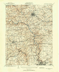
~ West Chester PA topo map, 1:62500 scale, 15 X 15 Minute, Historical, 1901, updated 1958
West Chester, Pennsylvania, USGS topographic map dated 1901.
Includes geographic coordinates (latitude and longitude). This topographic map is suitable for hiking, camping, and exploring, or framing it as a wall map.
Printed on-demand using high resolution imagery, on heavy weight and acid free paper, or alternatively on a variety of synthetic materials.
Topos available on paper, Waterproof, Poly, or Tyvek. Usually shipping rolled, unless combined with other folded maps in one order.
- Product Number: USGS-5331830
- Free digital map download (high-resolution, GeoPDF): West Chester, Pennsylvania (file size: 9 MB)
- Map Size: please refer to the dimensions of the GeoPDF map above
- Weight (paper map): ca. 55 grams
- Map Type: POD USGS Topographic Map
- Map Series: HTMC
- Map Verison: Historical
- Cell ID: 64403
- Scan ID: 222473
- Imprint Year: 1958
- Datum: NAD27
- Map Projection: Polyconic
- Map published by United States Geological Survey
- Map Language: English
- Scanner Resolution: 600 dpi
- Map Cell Name: West Chester
- Grid size: 15 X 15 Minute
- Date on map: 1901
- Map Scale: 1:62500
- Geographical region: Pennsylvania, United States
Neighboring Maps:
All neighboring USGS topo maps are available for sale online at a variety of scales.
Spatial coverage:
Topo map West Chester, Pennsylvania, covers the geographical area associated the following places:
- North Hills - Heatherbrooke - Northwood - Forest Hills Park - Tenby Chase - Gallagherville - Ward - Dutts Mill - Cardiff - Wawaset - North Star - Windon - Revolutionary Farm - Holly Knoll - Caswallen - Cornish Hills - Phillips Heights - Meriweather Farms - Century Farms - Weber Tract - Dilworthtown Woods - Green Lane Village - Jarrell Farms - Manley - Cider Knoll - Green Hill - Bridlewood Farm - Monroe Park - Granogue - Dartmouth Woods II - Hyllwynd - Fox Meadow - Deerhurst - Oak Lane Manor - Guyencourt - Brandywine Hills - West Goshen Hills - Westwood Manor - Ashwell - Chatham - Marshallton - Winterthur - Westminster - Pocopson - Woodbrook - Brandywine Forge - Village of Rocky Run - Brandywine Commons - Weldin Farms - Parkersville - Sharpless Farms - Hillcrest - Limestone Hills - Barley Woods - Rockland Woods - Bellefonte - Cricket Hill - Winterbury - Mendenhall Village - Goshen West - Lynnfield - Chadds Ford West - Heartsease - Hockessin Park - Berkeley Ridge - Williamsburg Court - Calais Woods - Rockwood Woods - Rosedale - Plumly Farms - Graylyn Crest - Talleys Corner - Worington Commons - Birdwood Hill - Madelyn Gardens - West Goshen - Thornbury - Pennington - Naamans Gardens - Galewood - Mill Creek - Beacon Hill North - Bridleshire Farms - Benton - Hollingsworth Development - Carrcroft - Painters Crossing - Yorklyn - Pleasant Grove - Blue Rock Manor - Yorklyn Ridge - Jerrehian Estates - Pentland - Meeting House Hill - Centerville - Westmount - Westtown - Sharpley - Loveville - Thornbury Knoll
- Map Area ID: AREA4039.75-75.75-75.5
- Northwest corner Lat/Long code: USGSNW40-75.75
- Northeast corner Lat/Long code: USGSNE40-75.5
- Southwest corner Lat/Long code: USGSSW39.75-75.75
- Southeast corner Lat/Long code: USGSSE39.75-75.5
- Northern map edge Latitude: 40
- Southern map edge Latitude: 39.75
- Western map edge Longitude: -75.75
- Eastern map edge Longitude: -75.5


