
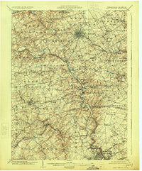
~ West Chester PA topo map, 1:62500 scale, 15 X 15 Minute, Historical, 1904, updated 1924
West Chester, Pennsylvania, USGS topographic map dated 1904.
Includes geographic coordinates (latitude and longitude). This topographic map is suitable for hiking, camping, and exploring, or framing it as a wall map.
Printed on-demand using high resolution imagery, on heavy weight and acid free paper, or alternatively on a variety of synthetic materials.
Topos available on paper, Waterproof, Poly, or Tyvek. Usually shipping rolled, unless combined with other folded maps in one order.
- Product Number: USGS-5331826
- Free digital map download (high-resolution, GeoPDF): West Chester, Pennsylvania (file size: 9 MB)
- Map Size: please refer to the dimensions of the GeoPDF map above
- Weight (paper map): ca. 55 grams
- Map Type: POD USGS Topographic Map
- Map Series: HTMC
- Map Verison: Historical
- Cell ID: 64403
- Scan ID: 170096
- Imprint Year: 1924
- Survey Year: 1901
- Datum: NAD
- Map Projection: Polyconic
- Map published by United States Geological Survey
- Map Language: English
- Scanner Resolution: 600 dpi
- Map Cell Name: West Chester
- Grid size: 15 X 15 Minute
- Date on map: 1904
- Map Scale: 1:62500
- Geographical region: Pennsylvania, United States
Neighboring Maps:
All neighboring USGS topo maps are available for sale online at a variety of scales.
Spatial coverage:
Topo map West Chester, Pennsylvania, covers the geographical area associated the following places:
- Calais Woods - Glenhall - Edenridge - Centreville Tract - Haverford - Brookfield - Green Meadow - Ways Corner - Cossart Creek - Dilworthtown Woods - Highland Meadows - Pin Oak Farms - Cardiff - Plumly Farms - Forwood - Lenape - Twin Bridge Farm - Milltown - Johnsons Corner - Talley Brook - Manley - Penns Grant - Colonial Woods - Guyencourt - Thornbury Hunt - Arborlea - Rocky Hill - Westwood Manor - Ward - Mockingbird Hills - Hickory Ridge - Goshen West - Ashwell - Perth - Sconnelltown - The Ridings of Chadds Ford - Birmingham Estates - Meeting House Meadows - Edgewood Hills - Brinton Woods - Phillips Heights - Pembrey - Goshenville - The Knolls of Birmingham - Sharpless Farms - Delwynn - Twin Oaks - Copesville - Lamatan I - Bella Vista - Thornbury - Woodcock Farm - Westover Hills - Suburban Village - Ringfield - Stonehaven - Greenville Development - Coventry Village - Unionville - Commons at Goshen - Westgate Farms - Birdwood Hill - Brandywine Summit - Fair Meadow - Rockland Woods - Saverys Mill - Hollingsworth Development - Heatherton - Twin Creeks at Mendenhall - Painters Crossroads - Westover Farms - Church Hill - Marshallton - Rock Manor - Willowdale - Smithfield Estates - Century Farms - Brookcroft - Dilworthtown - Holly Knoll - Augustine - Rockwood Hills - Surrey Park - Cornish Hills - Nanticoke Farms - Thornton - Carrcroft Crest - Stuyvesant Hills - Concord Hills - Longwood - Horseshoe Hill - Elam - Mendenhall - North Hills - Fieldpoint - Keepsake - Normandy Manor - Fox Meadow - Hockessin - Chatham
- Map Area ID: AREA4039.75-75.75-75.5
- Northwest corner Lat/Long code: USGSNW40-75.75
- Northeast corner Lat/Long code: USGSNE40-75.5
- Southwest corner Lat/Long code: USGSSW39.75-75.75
- Southeast corner Lat/Long code: USGSSE39.75-75.5
- Northern map edge Latitude: 40
- Southern map edge Latitude: 39.75
- Western map edge Longitude: -75.75
- Eastern map edge Longitude: -75.5


