
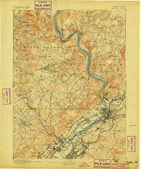
~ Pittston PA topo map, 1:62500 scale, 15 X 15 Minute, Historical, 1893, updated 1899
Pittston, Pennsylvania, USGS topographic map dated 1893.
Includes geographic coordinates (latitude and longitude). This topographic map is suitable for hiking, camping, and exploring, or framing it as a wall map.
Printed on-demand using high resolution imagery, on heavy weight and acid free paper, or alternatively on a variety of synthetic materials.
Topos available on paper, Waterproof, Poly, or Tyvek. Usually shipping rolled, unless combined with other folded maps in one order.
- Product Number: USGS-5331254
- Free digital map download (high-resolution, GeoPDF): Pittston, Pennsylvania (file size: 11 MB)
- Map Size: please refer to the dimensions of the GeoPDF map above
- Weight (paper map): ca. 55 grams
- Map Type: POD USGS Topographic Map
- Map Series: HTMC
- Map Verison: Historical
- Cell ID: 61043
- Scan ID: 169954
- Imprint Year: 1899
- Survey Year: 1890
- Datum: Unstated
- Map Projection: Unstated
- Map published by United States Geological Survey
- Map Language: English
- Scanner Resolution: 600 dpi
- Map Cell Name: Pittston
- Grid size: 15 X 15 Minute
- Date on map: 1893
- Map Scale: 1:62500
- Geographical region: Pennsylvania, United States
Neighboring Maps:
All neighboring USGS topo maps are available for sale online at a variety of scales.
Spatial coverage:
Topo map Pittston, Pennsylvania, covers the geographical area associated the following places:
- West Pittston - Ransom - Port Griffith - Laflin - Keystone - Back Mountain - Kingston - Wyoanna - Exeter - Maplewood Heights - Keelersburg - Kunkle - Trucksville - Milwaukee - Yatesville - Browntown - Plainsville - Forty Fort - Hudson - Carverton - Wyoming - Fox Hill - Orange - Hillside - Shaffers Corners - Druid Hills - Ridgewood - Old Boston - Ketcham - Port Bowkley - Edwardsville - Hilldale - Hughestown - Beaumont - Pittston - West Falls - Newton Center - Ewen - Swoyersville - Midvale - Shavertown - Chase - Schultzville - Gregory - Jenks - Parsons - Westminster - Port Blanchard - Dickville - West Wyoming - Miners Mills - Cork Lane - Pringle - Vernon - Luzerne - Lockville - Dallas - Mill City (historical) - Trucksville Gardens - Courtdale - Falls - South Eaton - Center Moreland - Harding - Hoban Heights - Hays Corner - Inkerman - Plains - Demunds Corners - Mount Airy Terrace - Mill City - Pittston Junction - Sebastopol - Happy Valley - Fern Brook - Upper Pittston - Huntsville - Upper Exeter
- Map Area ID: AREA41.541.25-76-75.75
- Northwest corner Lat/Long code: USGSNW41.5-76
- Northeast corner Lat/Long code: USGSNE41.5-75.75
- Southwest corner Lat/Long code: USGSSW41.25-76
- Southeast corner Lat/Long code: USGSSE41.25-75.75
- Northern map edge Latitude: 41.5
- Southern map edge Latitude: 41.25
- Western map edge Longitude: -76
- Eastern map edge Longitude: -75.75


