
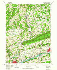
~ Bloomsburg PA topo map, 1:62500 scale, 15 X 15 Minute, Historical, 1954, updated 1967
Bloomsburg, Pennsylvania, USGS topographic map dated 1954.
Includes geographic coordinates (latitude and longitude). This topographic map is suitable for hiking, camping, and exploring, or framing it as a wall map.
Printed on-demand using high resolution imagery, on heavy weight and acid free paper, or alternatively on a variety of synthetic materials.
Topos available on paper, Waterproof, Poly, or Tyvek. Usually shipping rolled, unless combined with other folded maps in one order.
- Product Number: USGS-5329438
- Free digital map download (high-resolution, GeoPDF): Bloomsburg, Pennsylvania (file size: 9 MB)
- Map Size: please refer to the dimensions of the GeoPDF map above
- Weight (paper map): ca. 55 grams
- Map Type: POD USGS Topographic Map
- Map Series: HTMC
- Map Verison: Historical
- Cell ID: 51537
- Scan ID: 170331
- Imprint Year: 1967
- Woodland Tint: Yes
- Aerial Photo Year: 1942
- Field Check Year: 1944
- Datum: NAD27
- Map Projection: Polyconic
- Map published by United States Geological Survey
- Map Language: English
- Scanner Resolution: 600 dpi
- Map Cell Name: Bloomsburg
- Grid size: 15 X 15 Minute
- Date on map: 1954
- Map Scale: 1:62500
- Geographical region: Pennsylvania, United States
Neighboring Maps:
All neighboring USGS topo maps are available for sale online at a variety of scales.
Spatial coverage:
Topo map Bloomsburg, Pennsylvania, covers the geographical area associated the following places:
- Summer Hill - North Centre - Paper Mill - Martzville - Asbury - Rohrsburg - Fernville - Zaner - Pealertown - Cambra - Southdale - Fowlersville - Orangeville - Millertown - Willow Springs - Light Street - Fairmount Springs - Bendertown - Register - Marshall Hollow - Mifflinville - Briar Creek - Stillwater - Five Points - Welliversville - Bloomsburg - Coles Creek - Espy - Greenwood - Clarks View - Almedia - New Columbus - Jonestown - Honeytown - Jackson - Hetlerville - Mordansville - Benton - Polkville - Town Hill - Lime Ridge - Talmer - Waller - Evansville - Sky View Acres - Waterville - Coles Mill - Derrs - Dennis Mills - Maple Grove
- Map Area ID: AREA41.2541-76.5-76.25
- Northwest corner Lat/Long code: USGSNW41.25-76.5
- Northeast corner Lat/Long code: USGSNE41.25-76.25
- Southwest corner Lat/Long code: USGSSW41-76.5
- Southeast corner Lat/Long code: USGSSE41-76.25
- Northern map edge Latitude: 41.25
- Southern map edge Latitude: 41
- Western map edge Longitude: -76.5
- Eastern map edge Longitude: -76.25


