
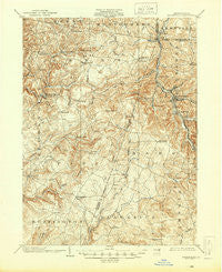
~ Barnesboro PA topo map, 1:62500 scale, 15 X 15 Minute, Historical, 1904, updated 1945
Barnesboro, Pennsylvania, USGS topographic map dated 1904.
Includes geographic coordinates (latitude and longitude). This topographic map is suitable for hiking, camping, and exploring, or framing it as a wall map.
Printed on-demand using high resolution imagery, on heavy weight and acid free paper, or alternatively on a variety of synthetic materials.
Topos available on paper, Waterproof, Poly, or Tyvek. Usually shipping rolled, unless combined with other folded maps in one order.
- Product Number: USGS-5329356
- Free digital map download (high-resolution, GeoPDF): Barnesboro, Pennsylvania (file size: 9 MB)
- Map Size: please refer to the dimensions of the GeoPDF map above
- Weight (paper map): ca. 55 grams
- Map Type: POD USGS Topographic Map
- Map Series: HTMC
- Map Verison: Historical
- Cell ID: 50951
- Scan ID: 168093
- Imprint Year: 1945
- Survey Year: 1902
- Datum: NAD
- Map Projection: Polyconic
- Map published by United States Geological Survey
- Map Language: English
- Scanner Resolution: 600 dpi
- Map Cell Name: Barnesboro
- Grid size: 15 X 15 Minute
- Date on map: 1904
- Map Scale: 1:62500
- Geographical region: Pennsylvania, United States
Neighboring Maps:
All neighboring USGS topo maps are available for sale online at a variety of scales.
Spatial coverage:
Topo map Barnesboro, Pennsylvania, covers the geographical area associated the following places:
- Spangler - Pindleton - Purchase Line - Red Mill - Pineton - Griffithtown - Alverda - Edwards Crossing - Colver - Spruce - Barnes - Preisser Crossing - Cush Cushion Crossing - Northern Cambria - McKeages Crossing - Fleming Summit - Long Run - Buck Run - Seamentown - Lovejoy - Vetera - Uniontown - West Branch - Stiles Crossing - Mentcle - Twenty Row - Watkins - Kenwood - Greenwich - Regan Junction - Cherry Tree - Wandin Junction - Tripoli - Ewings Mill - White Mill Crossing - Barnesboro - Diamondville - Nicktown - Bakersville - Blue Goose - Manor - Belsano Crossing - Allport - Garmantown - Taylorsville - Adams Crossing - Grisemore - Charlies Grove - Martintown - Learn Settlement - Kinter Crossing - Commodore - Jewtown - Nine Row - Heilwood - North Barnesboro - Emeigh - Bencetown - Pine Flats - Belsano - Strongstown - Starford - Stifflertown - Cookport - Seldersville - Shazen - Concrete Bridge Crossing - Nolo - Marsteller
- Map Area ID: AREA40.7540.5-79-78.75
- Northwest corner Lat/Long code: USGSNW40.75-79
- Northeast corner Lat/Long code: USGSNE40.75-78.75
- Southwest corner Lat/Long code: USGSSW40.5-79
- Southeast corner Lat/Long code: USGSSE40.5-78.75
- Northern map edge Latitude: 40.75
- Southern map edge Latitude: 40.5
- Western map edge Longitude: -79
- Eastern map edge Longitude: -78.75


