
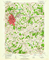
~ West Chester PA topo map, 1:24000 scale, 7.5 X 7.5 Minute, Historical, 1954, updated 1962
West Chester, Pennsylvania, USGS topographic map dated 1954.
Includes geographic coordinates (latitude and longitude). This topographic map is suitable for hiking, camping, and exploring, or framing it as a wall map.
Printed on-demand using high resolution imagery, on heavy weight and acid free paper, or alternatively on a variety of synthetic materials.
Topos available on paper, Waterproof, Poly, or Tyvek. Usually shipping rolled, unless combined with other folded maps in one order.
- Product Number: USGS-5328710
- Free digital map download (high-resolution, GeoPDF): West Chester, Pennsylvania (file size: 12 MB)
- Map Size: please refer to the dimensions of the GeoPDF map above
- Weight (paper map): ca. 55 grams
- Map Type: POD USGS Topographic Map
- Map Series: HTMC
- Map Verison: Historical
- Cell ID: 48159
- Scan ID: 222479
- Imprint Year: 1962
- Woodland Tint: Yes
- Aerial Photo Year: 1950
- Field Check Year: 1954
- Datum: NAD27
- Map Projection: Polyconic
- Map published by United States Geological Survey
- Map Language: English
- Scanner Resolution: 600 dpi
- Map Cell Name: West Chester
- Grid size: 7.5 X 7.5 Minute
- Date on map: 1954
- Map Scale: 1:24000
- Geographical region: Pennsylvania, United States
Neighboring Maps:
All neighboring USGS topo maps are available for sale online at a variety of scales.
Spatial coverage:
Topo map West Chester, Pennsylvania, covers the geographical area associated the following places:
- Hunt Country - Wylie Farms - Worington Commons - Painters Crossing - Plumly Farms - Wyllpen Farms - Grace Villa - Twin Creeks at Mendenhall - Grand Oak Run - Century Farms - Goshen West - Birmingham Estates - Serpentine Acres - Brandywine Hunt - West Goshen Park - Birmingham - West Goshen - Jerrehian Estates - Heartsease - Westtown Country Estates - Sugartown - Fern Hill - Green Lane Village - West Chester - Hilloch Manor - Woodcrest - Brandywine at Thornbury - Memel Farms - Thornbury Hunt - Fair Acres Farm - White Chimneys - Thornbury - Westtown Park - Goshen Commons - Cider Knoll - Westover Farms - Fair Meadow - Dilworthtown Oak Estates - Westtown - Clock Tower Woods - Thornton - Dutton Mill - Reserve at Chadds Ford - Dutts Mill - Locksley Crossing - Woodcock Farm - Tiberton - Milltown - Green Hill - West Wynn - Westtown Knoll - Roundelay - Thornbury Knoll - Kirby Woods - Tanguy - Marydell Farms - Suburban Village - Carriages at Cobblestones - Strasburg Court - Westtown Acres - Caswallen - Hamilton Place - Markham - Ashbridge Farms - Windmere Place - Rockland Village I and II - Pleasant Grove - Pin Oak Farms - Westtown Hillside - Pamona Park - Rollinwood - Dilworthtown - Twin Bridge Farm - Pepple - Painters Crossroads - Locksley - Seal - Rocky Hill - Westmount - Bow Tree - Revolutionary Farm - Hummingbird Farm - West Goshen Hills - Brinton Woods - Concordville - Hyllwynd - Oakbourne - Fieldpoint - Coventry Village - Cobblestones at Thornbury - Goshen Terrace - Birmingham Hunt - Greenbriar at Thornbury - Bridlewood Farm - Ashwell - Dilworthtown Woods - Shiloh Woods - Windon - Green Manor Farm - Darlington Corners
- Map Area ID: AREA4039.875-75.625-75.5
- Northwest corner Lat/Long code: USGSNW40-75.625
- Northeast corner Lat/Long code: USGSNE40-75.5
- Southwest corner Lat/Long code: USGSSW39.875-75.625
- Southeast corner Lat/Long code: USGSSE39.875-75.5
- Northern map edge Latitude: 40
- Southern map edge Latitude: 39.875
- Western map edge Longitude: -75.625
- Eastern map edge Longitude: -75.5


