
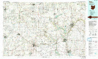
~ Piqua OH topo map, 1:100000 scale, 30 X 60 Minute, Historical, 1986, updated 1992
Piqua, Ohio, USGS topographic map dated 1986.
Includes geographic coordinates (latitude and longitude). This topographic map is suitable for hiking, camping, and exploring, or framing it as a wall map.
Printed on-demand using high resolution imagery, on heavy weight and acid free paper, or alternatively on a variety of synthetic materials.
Topos available on paper, Waterproof, Poly, or Tyvek. Usually shipping rolled, unless combined with other folded maps in one order.
- Product Number: USGS-5321526
- Free digital map download (high-resolution, GeoPDF): Piqua, Ohio (file size: 20 MB)
- Map Size: please refer to the dimensions of the GeoPDF map above
- Weight (paper map): ca. 55 grams
- Map Type: POD USGS Topographic Map
- Map Series: HTMC
- Map Verison: Historical
- Cell ID: 68155
- Scan ID: 228052
- Imprint Year: 1992
- Woodland Tint: Yes
- Photo Inspection Year: 1989
- Aerial Photo Year: 1989
- Edit Year: 1986
- Datum: NAD27
- Map Projection: Universal Transverse Mercator
- Map published by United States Geological Survey
- Map Language: English
- Scanner Resolution: 600 dpi
- Map Cell Name: Piqua
- Grid size: 30 X 60 Minute
- Date on map: 1986
- Map Scale: 1:100000
- Geographical region: Ohio, United States
Neighboring Maps:
All neighboring USGS topo maps are available for sale online at a variety of scales.
Spatial coverage:
Topo map Piqua, Ohio, covers the geographical area associated the following places:
- Spirk Mobile Home Park - Laurel Creek - Windridge Place - Greenville - Union City - Westridge - Brook Park North - Rural - Coletown - Clark - Newport - Crete - Carriage Crossing - Culbertson Heights - Saint Rosa - Valentine (historical) - Meadowrun - Bears Mill - Sherwood Manor - Premwood - Wakefield - Bucks Corner - Palestine - Glen Karn - Clayton - Arbar Acres - Nottingham - Maplecrest - Pleasant View - Conwood Estates - Lynn - Port Jefferson - Stony Ridge - Mount Pleasant (historical) - Nottinghill - Woodington - Sharps Crossing - College Corner - Broadway Mobile Court - Sebastian - Baker - Antiville - Abbottsville - Colonial Mobile Home Park - Hill Grove - Northfield - Hegemanns Landing - Saint Patrick - Ridgewood - Anna - Philothea - Olwine Mobile Home Park - Mount Jefferson - Monterey - Boundary City - Liber - Green Villa Mobile Park - Midway - Frenchtown - Westchester - Hunchberger Corners - Rossville - Twin Lakes (historical) - D and S Mobile Village - Plattsville - McCartyville - Uno - Antioch - Egypt - Coldwater - Cloverdale - Northumberland (historical) - Tampico - Strakers (historical) - Frys Corners - Alcony - Lena - Haysville Corner - Meadowlawn - New Knoxville - Lakeside Village - Weavers - Lehmkuhl Landing - Sidney - New Harrison - Brookside - Fairfield - Rose Hill - Nashville - Horatio - Wendelin - Spartanburg - Sharpsburg - Edgehill - Union City Mobile Home Park - Brock - Jackson Center - Summitville (historical) - Stonebridge - Heritage Hill
- Map Area ID: AREA40.540-85-84
- Northwest corner Lat/Long code: USGSNW40.5-85
- Northeast corner Lat/Long code: USGSNE40.5-84
- Southwest corner Lat/Long code: USGSSW40-85
- Southeast corner Lat/Long code: USGSSE40-84
- Northern map edge Latitude: 40.5
- Southern map edge Latitude: 40
- Western map edge Longitude: -85
- Eastern map edge Longitude: -84


