
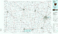
~ Lima OH topo map, 1:100000 scale, 30 X 60 Minute, Historical, 1986, updated 1986
Lima, Ohio, USGS topographic map dated 1986.
Includes geographic coordinates (latitude and longitude). This topographic map is suitable for hiking, camping, and exploring, or framing it as a wall map.
Printed on-demand using high resolution imagery, on heavy weight and acid free paper, or alternatively on a variety of synthetic materials.
Topos available on paper, Waterproof, Poly, or Tyvek. Usually shipping rolled, unless combined with other folded maps in one order.
- Product Number: USGS-5321506
- Free digital map download (high-resolution, GeoPDF): Lima, Ohio (file size: 15 MB)
- Map Size: please refer to the dimensions of the GeoPDF map above
- Weight (paper map): ca. 55 grams
- Map Type: POD USGS Topographic Map
- Map Series: HTMC
- Map Verison: Historical
- Cell ID: 67846
- Scan ID: 225901
- Imprint Year: 1986
- Aerial Photo Year: 1981
- Edit Year: 1986
- Datum: NAD27
- Map Projection: Universal Transverse Mercator
- Planimetric: Yes
- Map published by United States Geological Survey
- Map Language: English
- Scanner Resolution: 600 dpi
- Map Cell Name: Lima
- Grid size: 30 X 60 Minute
- Date on map: 1986
- Map Scale: 1:100000
- Geographical region: Ohio, United States
Neighboring Maps:
All neighboring USGS topo maps are available for sale online at a variety of scales.
Spatial coverage:
Topo map Lima, Ohio, covers the geographical area associated the following places:
- Shawnee Mobile Home Park - Rockport - Montezuma Acres - Cridersville - Ottoville - Wabash - Delphos - Wapakoneta - Fort Shawnee - Gettman Trailer Park - Boston Corner - Bursville - Williams - West Cairo - Coldwater Beach - Wren - Hume - Scotts Crossing - Scott - Venedocia - Middlebury - Parker Shady Acres Mobile Home Park - Cridersville Trailer Park - Bass Landing - Clevengers (historical) - Moulton - Padua - Village Courts II - Buckland - Converse Station - Striptown (historical) - South Shore Acres - Colony Mobile Home Park - Northwood - Gomer - Uniopolis - Bell Avenue Trailer Court - Saint Johns - Do Well Mobile Village - Barlage Trailer Park - Rushmore - Schumm - Jonestown - Trinity - Abanaka - Fort Jennings - Ceylon - Highland Park - Paradise Court - Royal Crest Mobile Home Park - Elida - Idlewild - Doss Landing - Southmoor Shores - Neptune - Spall's Mobile Home Village - Northwood Mobile Home Court - Harbor Point - Dull - Middle Point - Glynwood - Walton Mobile Home Court - Duckfoot Landing - Lees Landing - Scudder - Salem - Elmview - Elgin - Hartford (historical) - Monroeville - Needmore (historical) - Sandy Beach - Ulm's Mobile Home Court II - Van Wert - Hechts Landing - Kossuth - Four Seasons Trailer Park - Erastus - Willshire - Skeels Crossroads - Shively - Brehm (historical) - Breezewood - Spencerville - Bulkhead - Ulm's Mobile Home Court I - Reese's Mobile Home Park (historical) - Pleasant Mills - Shasta (historical) - Lima - Lakeland Beach - Bryant - Cole's Trailer Park - Harmons Landing - Landeck - Cavett - Southworth - Woodlawn Trailer Park Number 2 - Innwood Mobile Home Park - Sherwood Forest
- Map Area ID: AREA4140.5-85-84
- Northwest corner Lat/Long code: USGSNW41-85
- Northeast corner Lat/Long code: USGSNE41-84
- Southwest corner Lat/Long code: USGSSW40.5-85
- Southeast corner Lat/Long code: USGSSE40.5-84
- Northern map edge Latitude: 41
- Southern map edge Latitude: 40.5
- Western map edge Longitude: -85
- Eastern map edge Longitude: -84


