
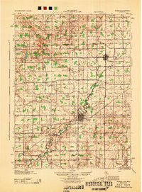
~ Pioneer OH topo map, 1:62500 scale, 15 X 15 Minute, Historical, 1944
Pioneer, Ohio, USGS topographic map dated 1944.
Includes geographic coordinates (latitude and longitude). This topographic map is suitable for hiking, camping, and exploring, or framing it as a wall map.
Printed on-demand using high resolution imagery, on heavy weight and acid free paper, or alternatively on a variety of synthetic materials.
Topos available on paper, Waterproof, Poly, or Tyvek. Usually shipping rolled, unless combined with other folded maps in one order.
- Product Number: USGS-5321230
- Free digital map download (high-resolution, GeoPDF): Pioneer, Ohio (file size: 7 MB)
- Map Size: please refer to the dimensions of the GeoPDF map above
- Weight (paper map): ca. 55 grams
- Map Type: POD USGS Topographic Map
- Map Series: HTMC
- Map Verison: Historical
- Cell ID: 61026
- Scan ID: 227125
- Woodland Tint: Yes
- Aerial Photo Year: 1940
- Datum: NAD27
- Map Projection: Polyconic
- Map published by United States Army Corps of Engineers
- Map published by United States Department of War
- Map Language: English
- Scanner Resolution: 600 dpi
- Map Cell Name: Pioneer
- Grid size: 15 X 15 Minute
- Date on map: 1944
- Map Scale: 1:62500
- Geographical region: Ohio, United States
Neighboring Maps:
All neighboring USGS topo maps are available for sale online at a variety of scales.
Spatial coverage:
Topo map Pioneer, Ohio, covers the geographical area associated the following places:
- West Jefferson - West Woodly Addition - Nu-vision Trailer Park - Greyhound - Pioneer Mobile Home Park - Nettle Lake - Maplecrest - Montpelier - Pioneer - Hallock - Blakeslee - Manleys Subdivision - Pulaski - Lake Seneca - Grimms Subdivision - Austin - Hillcrest - Northwest - Ainger - Cox Subdivision - West View Subdivision - West Buffalo (historical) - Jim Town - Caster Subdivision - Holiday City - Cooney - Bridgewater Center - Deer Lick (historical) - Daft Subdivision
- Map Area ID: AREA41.7541.5-84.75-84.5
- Northwest corner Lat/Long code: USGSNW41.75-84.75
- Northeast corner Lat/Long code: USGSNE41.75-84.5
- Southwest corner Lat/Long code: USGSSW41.5-84.75
- Southeast corner Lat/Long code: USGSSE41.5-84.5
- Northern map edge Latitude: 41.75
- Southern map edge Latitude: 41.5
- Western map edge Longitude: -84.75
- Eastern map edge Longitude: -84.5


