
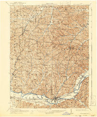
~ Newcomerstown OH topo map, 1:62500 scale, 15 X 15 Minute, Historical, 1913, updated 1943
Newcomerstown, Ohio, USGS topographic map dated 1913.
Includes geographic coordinates (latitude and longitude). This topographic map is suitable for hiking, camping, and exploring, or framing it as a wall map.
Printed on-demand using high resolution imagery, on heavy weight and acid free paper, or alternatively on a variety of synthetic materials.
Topos available on paper, Waterproof, Poly, or Tyvek. Usually shipping rolled, unless combined with other folded maps in one order.
- Product Number: USGS-5321160
- Free digital map download (high-resolution, GeoPDF): Newcomerstown, Ohio (file size: 11 MB)
- Map Size: please refer to the dimensions of the GeoPDF map above
- Weight (paper map): ca. 55 grams
- Map Type: POD USGS Topographic Map
- Map Series: HTMC
- Map Verison: Historical
- Cell ID: 58408
- Scan ID: 227703
- Imprint Year: 1943
- Survey Year: 1911
- Datum: NAD
- Map Projection: Polyconic
- Map published by United States Geological Survey
- Map Language: English
- Scanner Resolution: 600 dpi
- Map Cell Name: Newcomerstown
- Grid size: 15 X 15 Minute
- Date on map: 1913
- Map Scale: 1:62500
- Geographical region: Ohio, United States
Neighboring Maps:
All neighboring USGS topo maps are available for sale online at a variety of scales.
Spatial coverage:
Topo map Newcomerstown, Ohio, covers the geographical area associated the following places:
- Glasgow - Matthews Trailer Park - Newcomerstown - Yorktown - Baltic - Joyce - Village Court - Holly (historical) - Creekside Crossing - Fresno - Farmerstown - Bernice - Beaver Street Trailer Court - Ragersville - Stone Creek - Blackband - Isleta - Flat Iron Corner - Wolf - Pearl - Bakersville - Orange - Coalport - Port Washington - Shady Bend - Powell - Fiat - Mizers - Baltic Park Place
- Map Area ID: AREA40.540.25-81.75-81.5
- Northwest corner Lat/Long code: USGSNW40.5-81.75
- Northeast corner Lat/Long code: USGSNE40.5-81.5
- Southwest corner Lat/Long code: USGSSW40.25-81.75
- Southeast corner Lat/Long code: USGSSE40.25-81.5
- Northern map edge Latitude: 40.5
- Southern map edge Latitude: 40.25
- Western map edge Longitude: -81.75
- Eastern map edge Longitude: -81.5


