
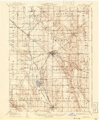
~ Medina OH topo map, 1:62500 scale, 15 X 15 Minute, Historical, 1906, updated 1941
Medina, Ohio, USGS topographic map dated 1906.
Includes geographic coordinates (latitude and longitude). This topographic map is suitable for hiking, camping, and exploring, or framing it as a wall map.
Printed on-demand using high resolution imagery, on heavy weight and acid free paper, or alternatively on a variety of synthetic materials.
Topos available on paper, Waterproof, Poly, or Tyvek. Usually shipping rolled, unless combined with other folded maps in one order.
- Product Number: USGS-5321104
- Free digital map download (high-resolution, GeoPDF): Medina, Ohio (file size: 7 MB)
- Map Size: please refer to the dimensions of the GeoPDF map above
- Weight (paper map): ca. 55 grams
- Map Type: POD USGS Topographic Map
- Map Series: HTMC
- Map Verison: Historical
- Cell ID: 57472
- Scan ID: 227838
- Imprint Year: 1941
- Survey Year: 1904
- Datum: NAD
- Map Projection: Polyconic
- Map published by United States Geological Survey
- Map Language: English
- Scanner Resolution: 600 dpi
- Map Cell Name: Medina
- Grid size: 15 X 15 Minute
- Date on map: 1906
- Map Scale: 1:62500
- Geographical region: Ohio, United States
Neighboring Maps:
All neighboring USGS topo maps are available for sale online at a variety of scales.
Spatial coverage:
Topo map Medina, Ohio, covers the geographical area associated the following places:
- Sherman Corners - Poe - Lester - Franks Corner - Friendsville - Weymouth - Windfall - J And M Trailer Court - Mallet Creek - Valley City Station - Chippewa Lake Park - Seville - Chippewa Lake - Medina - Westfield Center - Lafayette - River Styx - Valley City - Chamberlain (historical) - Briarwood Beach - Erhart - Gloria Glens Park - Blake - Brunswick - Boneta - Acme - Brookdale Mobile Home Park - Pliny (historical) - Chippewa-on-the-Lake - Abbeyville
- Map Area ID: AREA41.2541-82-81.75
- Northwest corner Lat/Long code: USGSNW41.25-82
- Northeast corner Lat/Long code: USGSNE41.25-81.75
- Southwest corner Lat/Long code: USGSSW41-82
- Southeast corner Lat/Long code: USGSSE41-81.75
- Northern map edge Latitude: 41.25
- Southern map edge Latitude: 41
- Western map edge Longitude: -82
- Eastern map edge Longitude: -81.75


