
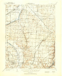
~ Mason OH topo map, 1:62500 scale, 15 X 15 Minute, Historical, 1904, updated 1958
Mason, Ohio, USGS topographic map dated 1904.
Includes geographic coordinates (latitude and longitude). This topographic map is suitable for hiking, camping, and exploring, or framing it as a wall map.
Printed on-demand using high resolution imagery, on heavy weight and acid free paper, or alternatively on a variety of synthetic materials.
Topos available on paper, Waterproof, Poly, or Tyvek. Usually shipping rolled, unless combined with other folded maps in one order.
- Product Number: USGS-5321066
- Free digital map download (high-resolution, GeoPDF): Mason, Ohio (file size: 7 MB)
- Map Size: please refer to the dimensions of the GeoPDF map above
- Weight (paper map): ca. 55 grams
- Map Type: POD USGS Topographic Map
- Map Series: HTMC
- Map Verison: Historical
- Cell ID: 57254
- Scan ID: 227808
- Imprint Year: 1958
- Survey Year: 1904
- Datum: NAD27
- Map Projection: Polyconic
- Map published by United States Geological Survey
- Map Language: English
- Scanner Resolution: 600 dpi
- Map Cell Name: Mason
- Grid size: 15 X 15 Minute
- Date on map: 1904
- Map Scale: 1:62500
- Geographical region: Ohio, United States
Neighboring Maps:
All neighboring USGS topo maps are available for sale online at a variety of scales.
Spatial coverage:
Topo map Mason, Ohio, covers the geographical area associated the following places:
- Busenbark - Foster - Bethany - Oakland - Country Acres - Maud - Millikin (historical) - Mayfield - Sharonville - Crestfield - Springdale - Twightwee - Circle View Acres - Sixteen Mile Stand - Concord Hills - Shadow Lake Village - Mason Mobile Home Park - Woodlawn - Greenlawn - Glendale - Snow Hill - Twenty Mile Stand - West Chester Woods - Wildwood Acres - South Excello - Evendale - Woodsdale - Linn-Crest Acres - Landen - Rockdale - Stokes (historical) - Le Sourdsville - Beckett Ridge - Shawnee Mobile Home Court - Otterbein - Grainthorpe (historical) - Flockton - Wetherington - Butterworth (historical) - Blue Ball - Princeton - Lemon - Dutchland Woods - Rialto - Tall Timber Estates - Airy Hills - Rolling Knolls - Gano - Miltomson - Jericho - Stonewall Estates - Trenton - Orchard Acres - Loveland Park - Rolling Woods - Tylersville - South Middletown - Huntsville - Bennington Place - Bon Veue - Kyles - Loveland - Ascot Downs - Robinhood Hills - Westchester - Hughes - Brecon - Hunting Creek Estates - Liberty Trails - Arbor Crest - Socialville - Pisgah - Port Union - Dalewood - Snidercrest - Sunburst Hills - Brookside Estates - Green Acres - Sycamore - Olde West Chester - Country Club Highlands - Emery Acres - North Excello - Monroe - Greystone - Highpoint - Oneida - Hazelwood - Taylor Village - Crescentville - Mason - Evergreen Farm Estates - Greentree Corners - Brookview - Hillcrest - Brenner Woods - Clearview - Hunter - Country View Estates - Brofield Estates
- Map Area ID: AREA39.539.25-84.5-84.25
- Northwest corner Lat/Long code: USGSNW39.5-84.5
- Northeast corner Lat/Long code: USGSNE39.5-84.25
- Southwest corner Lat/Long code: USGSSW39.25-84.5
- Southeast corner Lat/Long code: USGSSE39.25-84.25
- Northern map edge Latitude: 39.5
- Southern map edge Latitude: 39.25
- Western map edge Longitude: -84.5
- Eastern map edge Longitude: -84.25


