
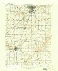
~ Lima OH topo map, 1:62500 scale, 15 X 15 Minute, Historical, 1906, updated 1943
Lima, Ohio, USGS topographic map dated 1906.
Includes geographic coordinates (latitude and longitude). This topographic map is suitable for hiking, camping, and exploring, or framing it as a wall map.
Printed on-demand using high resolution imagery, on heavy weight and acid free paper, or alternatively on a variety of synthetic materials.
Topos available on paper, Waterproof, Poly, or Tyvek. Usually shipping rolled, unless combined with other folded maps in one order.
- Product Number: USGS-5321018
- Free digital map download (high-resolution, GeoPDF): Lima, Ohio (file size: 6 MB)
- Map Size: please refer to the dimensions of the GeoPDF map above
- Weight (paper map): ca. 55 grams
- Map Type: POD USGS Topographic Map
- Map Series: HTMC
- Map Verison: Historical
- Cell ID: 56697
- Scan ID: 225590
- Imprint Year: 1943
- Visual Version Number: 2
- Survey Year: 1904
- Datum: Unstated
- Map Projection: Polyconic
- Map published by United States Geological Survey
- Map Language: English
- Scanner Resolution: 600 dpi
- Map Cell Name: Lima
- Grid size: 15 X 15 Minute
- Date on map: 1906
- Map Scale: 1:62500
- Geographical region: Ohio, United States
Neighboring Maps:
All neighboring USGS topo maps are available for sale online at a variety of scales.
Spatial coverage:
Topo map Lima, Ohio, covers the geographical area associated the following places:
- Indian Village Mobile Home Park - Bali Hai Mobile Home Park - Green Acres - Yoder - Cridersville - Geyer - Eastwood Estates - Shady Grove (historical) - Pusheta Town (historical) - Elmview - Reese's Mobile Home Park (historical) - Cridersville Trailer Park - Slater - Walton Mobile Home Court - Kemp - Fryburg - Four Seasons Trailer Park - Gutman - Offenbacher Mobile Home Park - Oakview - Saint Johns - Rousculp - Shawnee Mobile Home Park - Fort Shawnee - Royal Crest Mobile Home Park - Sherwood Forest - Hume - South Warsaw - Colony Mobile Home Park - Lima - Rineharts (historical) - Wapakoneta - Uniopolis - Country Estates - Colonial Estates
- Map Area ID: AREA40.7540.5-84.25-84
- Northwest corner Lat/Long code: USGSNW40.75-84.25
- Northeast corner Lat/Long code: USGSNE40.75-84
- Southwest corner Lat/Long code: USGSSW40.5-84.25
- Southeast corner Lat/Long code: USGSSE40.5-84
- Northern map edge Latitude: 40.75
- Southern map edge Latitude: 40.5
- Western map edge Longitude: -84.25
- Eastern map edge Longitude: -84


