
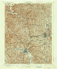
~ Jackson OH topo map, 1:62500 scale, 15 X 15 Minute, Historical, 1913, updated 1934
Jackson, Ohio, USGS topographic map dated 1913.
Includes geographic coordinates (latitude and longitude). This topographic map is suitable for hiking, camping, and exploring, or framing it as a wall map.
Printed on-demand using high resolution imagery, on heavy weight and acid free paper, or alternatively on a variety of synthetic materials.
Topos available on paper, Waterproof, Poly, or Tyvek. Usually shipping rolled, unless combined with other folded maps in one order.
- Product Number: USGS-5320970
- Free digital map download (high-resolution, GeoPDF): Jackson, Ohio (file size: 12 MB)
- Map Size: please refer to the dimensions of the GeoPDF map above
- Weight (paper map): ca. 55 grams
- Map Type: POD USGS Topographic Map
- Map Series: HTMC
- Map Verison: Historical
- Cell ID: 55828
- Scan ID: 225399
- Imprint Year: 1934
- Survey Year: 1911
- Datum: NAD
- Map Projection: Polyconic
- Map published by United States Geological Survey
- Map Language: English
- Scanner Resolution: 600 dpi
- Map Cell Name: Jackson
- Grid size: 15 X 15 Minute
- Date on map: 1913
- Map Scale: 1:62500
- Geographical region: Ohio, United States
Neighboring Maps:
All neighboring USGS topo maps are available for sale online at a variety of scales.
Spatial coverage:
Topo map Jackson, Ohio, covers the geographical area associated the following places:
- Petrea - Sharon - Latrobe (historical) - Tom Corwin - Bee (historical) - Ironton Junction - Maple Grove (historical) - Jackson - Ray - Hamden - Leo - Chapman - Altoona - Comet - Glen Roy - Ratchford - Garfield - Richland - Englishville - Byer - Goldsboro - Ridgeland - Wellston - Savageville - Roads - Lesmil - Glen Nell - Morgantown (historical) - Jackson Heights - Pine Grove - Oakland - Jonestown - Davisville - Buffalo - Coalton
- Map Area ID: AREA39.2539-82.75-82.5
- Northwest corner Lat/Long code: USGSNW39.25-82.75
- Northeast corner Lat/Long code: USGSNE39.25-82.5
- Southwest corner Lat/Long code: USGSSW39-82.75
- Southeast corner Lat/Long code: USGSSE39-82.5
- Northern map edge Latitude: 39.25
- Southern map edge Latitude: 39
- Western map edge Longitude: -82.75
- Eastern map edge Longitude: -82.5


