
~ Wisconsin Rapids WI topo map, 1:100000 scale, 30 X 60 Minute, Historical, 1985, updated 1985
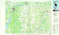
Wisconsin Rapids, Wisconsin, USGS topographic map dated 1985.
Includes geographic coordinates (latitude and longitude). This topographic map is suitable for hiking, camping, and exploring, or framing it as a wall map.
Printed on-demand using high resolution imagery, on heavy weight and acid free paper, or alternatively on a variety of synthetic materials.
Topos available on paper, Waterproof, Poly, or Tyvek. Usually shipping rolled, unless combined with other folded maps in one order.
- Product Number: USGS-5309828
- Free digital map download (high-resolution, GeoPDF): Wisconsin Rapids, Wisconsin (file size: 14 MB)
- Map Size: please refer to the dimensions of the GeoPDF map above
- Weight (paper map): ca. 55 grams
- Map Type: POD USGS Topographic Map
- Map Series: HTMC
- Map Verison: Historical
- Cell ID: 68611
- Scan ID: 803119
- Imprint Year: 1985
- Woodland Tint: Yes
- Aerial Photo Year: 1982
- Edit Year: 1985
- Datum: NAD27
- Map Projection: Universal Transverse Mercator
- Planimetric: Yes
- Map published by United States Geological Survey
- Map Language: English
- Scanner Resolution: 508 dpi
- Map Cell Name: Wisconsin Rapids
- Grid size: 30 X 60 Minute
- Date on map: 1985
- Map Scale: 1:100000
- Geographical region: Wisconsin, United States
Neighboring Maps:
All neighboring USGS topo maps are available for sale online at a variety of scales.
Spatial coverage:
Topo map Wisconsin Rapids, Wisconsin, covers the geographical area associated the following places:
- Kellner - Coddington - Bancroft - Port Edwards - Waupaca - Rome - Pine River - Little Hope - Chain O' Lakes - Lohrville - Big Flats - West Almond - West Bancroft - Sheridan - Wisconsin Rapids - Heffron - Eight Corners - Nelsonville - Amherst Junction - Lake Emily (historical) - King - Cottonville - Wild Rose - Plover - Rural - Roche a Cri (historical) - Lake Wazeecha - Rudolph - New Rome - Mount Morris - Hancock - New Rome (historical) - Parfreyville - Keene - Coloma - Nekoosa - Arkdale - Meehan - Walker - Spring Lake - Monroe Center - Scandinavia - Plainfield - Amherst - Redgranite - Saxeville - Vesper - Wautoma - Nekoosa Junction - Almond - Silver Lake - Cobb Town - Granite Quarry (historical) - Biron - Fancher - Ogdensburg - Blaine - Strongs Prairie - Richford - Arnott - Whiting
- Map Area ID: AREA44.544-90-89
- Northwest corner Lat/Long code: USGSNW44.5-90
- Northeast corner Lat/Long code: USGSNE44.5-89
- Southwest corner Lat/Long code: USGSSW44-90
- Southeast corner Lat/Long code: USGSSE44-89
- Northern map edge Latitude: 44.5
- Southern map edge Latitude: 44
- Western map edge Longitude: -90
- Eastern map edge Longitude: -89


