
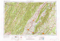
~ Charlottesville VA topo map, 1:250000 scale, 1 X 2 Degree, Historical, 1956, updated 1974
Charlottesville, Virginia, USGS topographic map dated 1956.
Includes geographic coordinates (latitude and longitude). This topographic map is suitable for hiking, camping, and exploring, or framing it as a wall map.
Printed on-demand using high resolution imagery, on heavy weight and acid free paper, or alternatively on a variety of synthetic materials.
Topos available on paper, Waterproof, Poly, or Tyvek. Usually shipping rolled, unless combined with other folded maps in one order.
- Product Number: USGS-5304192
- Free digital map download (high-resolution, GeoPDF): Charlottesville, Virginia (file size: 19 MB)
- Map Size: please refer to the dimensions of the GeoPDF map above
- Weight (paper map): ca. 55 grams
- Map Type: POD USGS Topographic Map
- Map Series: HTMC
- Map Verison: Historical
- Cell ID: 68712
- Scan ID: 189241
- Imprint Year: 1974
- Woodland Tint: Yes
- Edit Year: 1965
- Field Check Year: 1956
- Datum: Unstated
- Map Projection: Transverse Mercator
- Map published by United States Geological Survey
- Map Language: English
- Scanner Resolution: 600 dpi
- Map Cell Name: Charlottesville
- Grid size: 1 X 2 Degree
- Date on map: 1956
- Map Scale: 1:250000
- Geographical region: Virginia, United States
Neighboring Maps:
All neighboring USGS topo maps are available for sale online at a variety of scales.
Spatial coverage:
Topo map Charlottesville, Virginia, covers the geographical area associated the following places:
- Stemphleytown - Ferrol - Willoughby - Mount Clifton - Moscow - Sully - Honeyville - Dickensons Store - Oak Grove - Laurel Mills - Lumber (historical) - Brookwood - Getz Corner - Basore - Forest Hills - Buckners Corner - Chinquapin - Limeton - Ingham - Zigler - Friendship Heights - Shavertown - North Mountain - Williams Fork - Owensville - River View - Homeland - Sunrise - Roaring Creek Junction - Huntington Village - Orchard Acres - Green Bank - Greenwood - Circleville - Sullivan - Rediviva - Red Mills - Braucher - Armstrong - Lilly - Daphna - McMullen - McKinley - Mount Clinton - Windrift - Hinton - Broadway - Syria - Stony Bottom - Montes (historical) - Verona - Eldorada - Whispering Pines - Chester Gap - Elly - West Leigh - The Meadows - Lochridge - Pansy - Palos - Kings Crossing - Hawkinstown - Tryme - Lasley (historical) - Lewis Hill East - Damtown - Country Green - Lone Fountain - The Lions Den - Wakefield Manor - College Park - Hosterman - Dry Run - Turleytown - Madison Run - Clifton - Fort Defiance - Liberty Mills - Highland Park - Sangerville - Westover - White House - Viscose City - Alpine - Brinnington - Masonville - Stony Man - West Augusta - Wyoming (historical) - Hopeville - Glen Echo - Zirkle - Rosena - Northerly - Norman - West Woods - Clines Hacking - Chapin - Mustoe - Fort Seybert
- Map Area ID: AREA3938-80-78
- Northwest corner Lat/Long code: USGSNW39-80
- Northeast corner Lat/Long code: USGSNE39-78
- Southwest corner Lat/Long code: USGSSW38-80
- Southeast corner Lat/Long code: USGSSE38-78
- Northern map edge Latitude: 39
- Southern map edge Latitude: 38
- Western map edge Longitude: -80
- Eastern map edge Longitude: -78


