
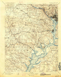
~ Mt Vernon VA topo map, 1:125000 scale, 30 X 30 Minute, Historical, 1894, updated 1926
Mt Vernon, Virginia, USGS topographic map dated 1894.
Includes geographic coordinates (latitude and longitude). This topographic map is suitable for hiking, camping, and exploring, or framing it as a wall map.
Printed on-demand using high resolution imagery, on heavy weight and acid free paper, or alternatively on a variety of synthetic materials.
Topos available on paper, Waterproof, Poly, or Tyvek. Usually shipping rolled, unless combined with other folded maps in one order.
- Product Number: USGS-5304032
- Free digital map download (high-resolution, GeoPDF): Mt Vernon, Virginia (file size: 7 MB)
- Map Size: please refer to the dimensions of the GeoPDF map above
- Weight (paper map): ca. 55 grams
- Map Type: POD USGS Topographic Map
- Map Series: HTMC
- Map Verison: Historical
- Cell ID: 320671
- Scan ID: 189090
- Imprint Year: 1926
- Survey Year: 1888
- Datum: NAD
- Map Projection: Polyconic
- Map published by United States Geological Survey
- Map Language: English
- Scanner Resolution: 600 dpi
- Map Cell Name: Mount Vernon
- Grid size: 30 X 30 Minute
- Date on map: 1894
- Map Scale: 1:125000
- Geographical region: Virginia, United States
Neighboring Maps:
All neighboring USGS topo maps are available for sale online at a variety of scales.
Spatial coverage:
Topo map Mt Vernon, Virginia, covers the geographical area associated the following places:
- Darbydale - Centreville - Donna Lee Gardens - Centreville Farms - Foxhall Crescent - Alexandria - River Bend Estates - Bell Forest - Silverdale - Lakewood - Featherstone - Chapman Landing - Crowells Corner - Dozer Mill Acres - Keene Mill Heights - Annandale Acres - Georgetown Heights (historical) - Sligo - Battery Park - Oak Grove - Hawthorne Manor - Morningside - Chesterbrook Gardens - The Heights - Mattawoman Woods - Lewis Subdivision (historical) - Colony Hill - Franconia - Wesley Heights - Sunnyview - Comptons Corner - Wellington Heights - Shenandoah - Governors Grove - Glendale - Armsleigh Park (historical) - Navy - Station Hills - Mount Vernon Woods - Country Club Grove - Mount Vernon - Marlo Heights - Tunlaw Heights (historical) - Elmwood Estates - Hells Bottom (historical) - Ilda - Glymont - Sunset Manor - Du-Mar Estates - Lorfax Heights - Youngsborough (historical) - Vienna Woods - Howard - Walters Woods - Great Falls - Mount Pisgah - Vernon Square - Scott Circle - Bethel - Alcova Heights - Riverview Village - Glencarlyn - Old Courthouse - Widowsville (historical) - Dixie Hill - Bucknell Manor - Chamberlain Village - Ridgedale - Country Club Manor - Foxhall Village - Country Place - Seven Corners - Strawberry Hills Estates - Bannockburn Estates - Gaila Woods - Belleair - Oakwood - Eutaw Forest - Garfield Estates - Mount Carmel - Cedar Crest - Sleepy Hollow Estates - Occoquan - Villa Del-Ray - Clermont Woods - Berry Hill Manor - Virginia Forest - Cloverdale - Sulgrave Manor - Wakefield Forest - Monticello Park - Indian Springs - Washington - Woodbridge - Addison Heights - Holmes Run Park - Four Corners - Fort Ward Heights - Springfield - Lee Manor
- Map Area ID: AREA3938.5-77.5-77
- Northwest corner Lat/Long code: USGSNW39-77.5
- Northeast corner Lat/Long code: USGSNE39-77
- Southwest corner Lat/Long code: USGSSW38.5-77.5
- Southeast corner Lat/Long code: USGSSE38.5-77
- Northern map edge Latitude: 39
- Southern map edge Latitude: 38.5
- Western map edge Longitude: -77.5
- Eastern map edge Longitude: -77


