
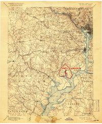
~ Mt Vernon VA topo map, 1:125000 scale, 30 X 30 Minute, Historical, 1894, updated 1918
Mt Vernon, Virginia, USGS topographic map dated 1894.
Includes geographic coordinates (latitude and longitude). This topographic map is suitable for hiking, camping, and exploring, or framing it as a wall map.
Printed on-demand using high resolution imagery, on heavy weight and acid free paper, or alternatively on a variety of synthetic materials.
Topos available on paper, Waterproof, Poly, or Tyvek. Usually shipping rolled, unless combined with other folded maps in one order.
- Product Number: USGS-5304030
- Free digital map download (high-resolution, GeoPDF): Mt Vernon, Virginia (file size: 8 MB)
- Map Size: please refer to the dimensions of the GeoPDF map above
- Weight (paper map): ca. 55 grams
- Map Type: POD USGS Topographic Map
- Map Series: HTMC
- Map Verison: Historical
- Cell ID: 320671
- Scan ID: 189086
- Imprint Year: 1918
- Survey Year: 1888
- Datum: Unstated
- Map Projection: Unstated
- Special Printing: Yes
- Map published by United States Geological Survey
- Map Language: English
- Scanner Resolution: 600 dpi
- Map Cell Name: Mount Vernon
- Grid size: 30 X 30 Minute
- Date on map: 1894
- Map Scale: 1:125000
- Geographical region: Virginia, United States
Neighboring Maps:
All neighboring USGS topo maps are available for sale online at a variety of scales.
Spatial coverage:
Topo map Mt Vernon, Virginia, covers the geographical area associated the following places:
- Lee Meadows - Judiciary Square - Addison Heights - Glymont - Woodley - Kings Park - Pinecrest - Brook Hill - Keene Mill Manor - Montclair - Holmes Run Park - McConchie - Bradmoor - Giesboro - Bent Tree Estates - Foxhall - Lynhaven - Bryan Point - Gunston Heights - Columbia Heights - Lynbrook - Potomac Mills - Capitol Hill - Bush Hill Woods - Woodlawn Manor - Cameron - Country Club Hills - Poplar Heights - Whitehall Manor - Weston (historical) - Cannon - Arcturus - McLean Hamlet - Indian Rock Terrace - Auburn - Pohick Park - Newton Woods - Glenbrook - North Springfield - Brockwood - Rollingwood - Rose Hill - Fair Oaks - Eutaw Forest - Laurel Hill - Billingsley Forest - Plantation Pines Estates - Rock Creek Gardens - The Heights - Pimmit Hills - Lindendale - Logan Circle - Barkers Crossroads - Westchester - Port Tobacco Hills - Westover - Fairchester - Marumsco Hills - Barcroft - Little River Hills - Lewis Park - Malbrook - Bristow - Belmont Park - Greenbriar - Point of Woods - Pender - Langley - The Cloisters - Gum Springs - Woodbine - Silverdale - Thomason Park - Braddock - Lee Boulevard Heights - McLean Manor - Kiels Gardens - Yorkshire Park - Tauxenent (historical) - Oakwood - Lincoln Park - Falls Hill - Lexington Estates - Breeden Forest - Limstrong - Triangle - Churchill - Edgewood - Woodbine Forest - Woodburn - Green Acres - Glen Forest - Foxhall Village - Seminary Valley - Windy Hill - Minnieville Estates - Southwest - Chapel Acres - White Oaks - Lake Jackson
- Map Area ID: AREA3938.5-77.5-77
- Northwest corner Lat/Long code: USGSNW39-77.5
- Northeast corner Lat/Long code: USGSNE39-77
- Southwest corner Lat/Long code: USGSSW38.5-77.5
- Southeast corner Lat/Long code: USGSSE38.5-77
- Northern map edge Latitude: 39
- Southern map edge Latitude: 38.5
- Western map edge Longitude: -77.5
- Eastern map edge Longitude: -77


