
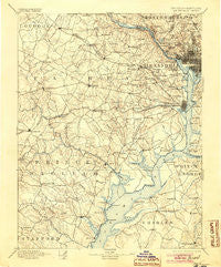
~ Mt Vernon VA topo map, 1:125000 scale, 30 X 30 Minute, Historical, 1894, updated 1904
Mt Vernon, Virginia, USGS topographic map dated 1894.
Includes geographic coordinates (latitude and longitude). This topographic map is suitable for hiking, camping, and exploring, or framing it as a wall map.
Printed on-demand using high resolution imagery, on heavy weight and acid free paper, or alternatively on a variety of synthetic materials.
Topos available on paper, Waterproof, Poly, or Tyvek. Usually shipping rolled, unless combined with other folded maps in one order.
- Product Number: USGS-5304022
- Free digital map download (high-resolution, GeoPDF): Mt Vernon, Virginia (file size: 7 MB)
- Map Size: please refer to the dimensions of the GeoPDF map above
- Weight (paper map): ca. 55 grams
- Map Type: POD USGS Topographic Map
- Map Series: HTMC
- Map Verison: Historical
- Cell ID: 320671
- Scan ID: 189080
- Imprint Year: 1904
- Survey Year: 1888
- Datum: Unstated
- Map Projection: Unstated
- Map published by United States Geological Survey
- Map Language: English
- Scanner Resolution: 600 dpi
- Map Cell Name: Mount Vernon
- Grid size: 30 X 30 Minute
- Date on map: 1894
- Map Scale: 1:125000
- Geographical region: Virginia, United States
Neighboring Maps:
All neighboring USGS topo maps are available for sale online at a variety of scales.
Spatial coverage:
Topo map Mt Vernon, Virginia, covers the geographical area associated the following places:
- Kiels Gardens - Dunlops Hills - Tauxenent (historical) - Drummond - Chevy Chase Section Three - Potomac Hills - Giesboro - Washington City - Uniontown - A Country Place - Lanier Heights - North Springfield - Holly Haven - Bryans Road - Enola - Ballston - Wesley Heights - Laurel Hill - Hells Bottom (historical) - Lindau Woods - Cedar Park - Marumsco Hills - Lunt - Vale - Woodmont - Thomas Circle - North Cleveland Park - Kenmore - Leewood - Chevy Chase Village - Yates Village - Hunters Square - Woodlea - Courtland Park - Minnieville Manor - Fort Myer Heights - Herndon - Kalorama Heights - Ilda - Windsor Estates - Broyhill Park - Woodley Hills - Metropolis View - Farrs Corner - Franconia - North Indian Head Estates - Capitol Hill - Reston - Springfield Oaks - Hollindale - Hunter - Somerset - Yorkshire Acres - Franklin - Landon Village - Foxridge - North Gate - Mount Hebron Park - Sleepy Hollow Manor - Parklawn - Rock Creek Gardens - Merrimack Park - Port Tobacco - Fairchester - Crestview - Bradley Woods - Kenwood - Quiet Acres - Hillcrest Estates - Bell Forest - Ripley - Fairview - Tyler Gardens - Woodbine Woods - Spring Hill - Guilford - Alpine - Shirlington - Woodlawn - Oak Park - Brentsville - Westchester - Montyville Estates - High Point - Wooded Acres - Waldon Woods - Chillum Station - Redhill - Pine Spring - Virginia Hills - Terrapin Forest - Cobbdale - Foggy Bottom - Whitehall Manor - Pohick Hills - Lee Manor - Wilton Woods - Farmington Road Estates - Glenbrook Knoll - Bloom Crossing
- Map Area ID: AREA3938.5-77.5-77
- Northwest corner Lat/Long code: USGSNW39-77.5
- Northeast corner Lat/Long code: USGSNE39-77
- Southwest corner Lat/Long code: USGSSW38.5-77.5
- Southeast corner Lat/Long code: USGSSE38.5-77
- Northern map edge Latitude: 39
- Southern map edge Latitude: 38.5
- Western map edge Longitude: -77.5
- Eastern map edge Longitude: -77


