
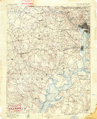
~ Mt Vernon VA topo map, 1:125000 scale, 30 X 30 Minute, Historical, 1890
Mt Vernon, Virginia, USGS topographic map dated 1890.
Includes geographic coordinates (latitude and longitude). This topographic map is suitable for hiking, camping, and exploring, or framing it as a wall map.
Printed on-demand using high resolution imagery, on heavy weight and acid free paper, or alternatively on a variety of synthetic materials.
Topos available on paper, Waterproof, Poly, or Tyvek. Usually shipping rolled, unless combined with other folded maps in one order.
- Product Number: USGS-5304014
- Free digital map download (high-resolution, GeoPDF): Mt Vernon, Virginia (file size: 8 MB)
- Map Size: please refer to the dimensions of the GeoPDF map above
- Weight (paper map): ca. 55 grams
- Map Type: POD USGS Topographic Map
- Map Series: HTMC
- Map Verison: Historical
- Cell ID: 320671
- Scan ID: 189076
- Survey Year: 1888
- Datum: Unstated
- Map Projection: Unstated
- Map published by United States Geological Survey
- Map Language: English
- Scanner Resolution: 600 dpi
- Map Cell Name: Mount Vernon
- Grid size: 30 X 30 Minute
- Date on map: 1890
- Map Scale: 1:125000
- Geographical region: Virginia, United States
Neighboring Maps:
All neighboring USGS topo maps are available for sale online at a variety of scales.
Spatial coverage:
Topo map Mt Vernon, Virginia, covers the geographical area associated the following places:
- Wessynton - Chevy Chase Heights - Fair Vernon - A Country Place - Brooke Manor - Walker Chapel - Broyhill-Langley Estates - Woodley Park - Bucknell Heights - Franconia - Elgin Corner - Goodacre Knolls - Potomac Heights - Franklin McPherson Square - Tantallon Hills - Country Place - Glendale - Cabin John Park - Langley Oaks - Adams Morgan - Edgewood - Hells Bottom (historical) - Vannoy Acres - Sutton Place - Tantallon Square - Belleair - Countryside - Wakefield - Princedale - Merrimack Park - Woodley Hills - Beverley Hills - Carrollsburg (historical) - Dumfries - Vernon Estates - Fostern Estates - Woodley North - Cleveland Park - Broyhill Park - Buckhall - Four Corners - Donovans Corner - Mount Vernon Woods - Woodbine - Shenandoah - Rivercrest - Greenway Hills - Emery Corners - Pomfret Estates - Brad Lee - Bannockburn Heights - Groveton - London Towne - Sideburn - Huntington - Mount Ida - Triangle - North Springfield - Fair Oaks - Columbia Park - Forest Hills - Mantua - Strathmeade Springs - Cameron - Malbrook - Bell Forest - Wilton Woods - Huntington - Fair Haven - Foxhall - Brentsville - Robeys Mill - Bluemont Junction - Harmony Hall - Billingsley Forest - McLean - Chevy Chase - Dalecrest - Schuyler Hills - Edsall Park - Belmont Park - Village of Mount Air - South Hampton Village - Glenbrook Knoll - Woodley Hills - Hunter - Limstrong - Sully Plantation - Berry Hill Manor - Spring Hill - Blevinstown - Hickory Creek - Mapledale - Fairfax Acres - Joplin - Woodhaven - Yorkshire Acres - Robeyville (historical) - Holly Park Estates - Indian Springs
- Map Area ID: AREA3938.5-77.5-77
- Northwest corner Lat/Long code: USGSNW39-77.5
- Northeast corner Lat/Long code: USGSNE39-77
- Southwest corner Lat/Long code: USGSSW38.5-77.5
- Southeast corner Lat/Long code: USGSSE38.5-77
- Northern map edge Latitude: 39
- Southern map edge Latitude: 38.5
- Western map edge Longitude: -77.5
- Eastern map edge Longitude: -77


