
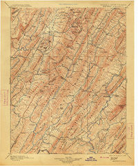
~ Monterey VA topo map, 1:125000 scale, 30 X 30 Minute, Historical, 1901, updated 1913
Monterey, Virginia, USGS topographic map dated 1901.
Includes geographic coordinates (latitude and longitude). This topographic map is suitable for hiking, camping, and exploring, or framing it as a wall map.
Printed on-demand using high resolution imagery, on heavy weight and acid free paper, or alternatively on a variety of synthetic materials.
Topos available on paper, Waterproof, Poly, or Tyvek. Usually shipping rolled, unless combined with other folded maps in one order.
- Product Number: USGS-5304002
- Free digital map download (high-resolution, GeoPDF): Monterey, Virginia (file size: 10 MB)
- Map Size: please refer to the dimensions of the GeoPDF map above
- Weight (paper map): ca. 55 grams
- Map Type: POD USGS Topographic Map
- Map Series: HTMC
- Map Verison: Historical
- Cell ID: 66084
- Scan ID: 189068
- Imprint Year: 1913
- Survey Year: 1887
- Datum: Unstated
- Map Projection: Unstated
- Map published by United States Geological Survey
- Map Language: English
- Scanner Resolution: 600 dpi
- Map Cell Name: Monterey
- Grid size: 30 X 30 Minute
- Date on map: 1901
- Map Scale: 1:125000
- Geographical region: Virginia, United States
Neighboring Maps:
All neighboring USGS topo maps are available for sale online at a variety of scales.
Spatial coverage:
Topo map Monterey, Virginia, covers the geographical area associated the following places:
- Bath Alum - Hotchkiss - Wanless - Clover Lick - Chimney Run - West Warm Springs - Buckeye (historical) - Deer Creek - Switch Back - Nida - Mitchelltown - Raywood - Bacova - Shiloh - Trimble - Bolar - Hosterman - Spruce - Williamsville - Armstrong - Green Bank - Naples (historical) - Mustoe - Green Valley - Vanderpool - Frost - McCowan Spring - Hightown - Possum Trot - Fort Lewis - Mountain Grove - Sunrise - Rimel - Minnehaha Springs - Yost - Dunns (historical) - Sunset (historical) - Warm Springs - New Hampden - Arbovale - Dilleys Mill - Sitlington - Bacova Junction - Crowdertown - Shanklin (historical) - Patna - Bethel - Dunmore - Meadowdale - Stony Bottom - Clover Creek - Mill Gap - Thomastown - Fort Lewis (historical) - McClung - Cass - Germantown (historical) - Monterey - Boyer - Burnsville - Cowardin (historical) - Mooretown
- Map Area ID: AREA38.538-80-79.5
- Northwest corner Lat/Long code: USGSNW38.5-80
- Northeast corner Lat/Long code: USGSNE38.5-79.5
- Southwest corner Lat/Long code: USGSSW38-80
- Southeast corner Lat/Long code: USGSSE38-79.5
- Northern map edge Latitude: 38.5
- Southern map edge Latitude: 38
- Western map edge Longitude: -80
- Eastern map edge Longitude: -79.5


