
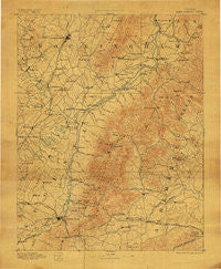
~ Harrisonburg VA topo map, 1:125000 scale, 30 X 30 Minute, Historical, 1892, updated 1907
Harrisonburg, Virginia, USGS topographic map dated 1892.
Includes geographic coordinates (latitude and longitude). This topographic map is suitable for hiking, camping, and exploring, or framing it as a wall map.
Printed on-demand using high resolution imagery, on heavy weight and acid free paper, or alternatively on a variety of synthetic materials.
Topos available on paper, Waterproof, Poly, or Tyvek. Usually shipping rolled, unless combined with other folded maps in one order.
- Product Number: USGS-5303918
- Free digital map download (high-resolution, GeoPDF): Harrisonburg, Virginia (file size: 8 MB)
- Map Size: please refer to the dimensions of the GeoPDF map above
- Weight (paper map): ca. 55 grams
- Map Type: POD USGS Topographic Map
- Map Series: HTMC
- Map Verison: Historical
- Cell ID: 65649
- Scan ID: 188999
- Imprint Year: 1907
- Survey Year: 1887
- Datum: Unstated
- Map Projection: Unstated
- Map published by United States Geological Survey
- Map Language: English
- Scanner Resolution: 600 dpi
- Map Cell Name: Harrisonburg
- Grid size: 30 X 30 Minute
- Date on map: 1892
- Map Scale: 1:125000
- Geographical region: Virginia, United States
Neighboring Maps:
All neighboring USGS topo maps are available for sale online at a variety of scales.
Spatial coverage:
Topo map Harrisonburg, Virginia, covers the geographical area associated the following places:
- Coakley Town - Annex - Newtown - Grottoes - Parkview - Furnace - Mayfield Trailer Court - Kingsbury Manor - Teaverton - Whispering Pines - Ladd - Solsburg - Broad Axe (historical) - Wilson Heights - Paulington (historical) - Mountfair - Lewis Hill West - Thurston - Westover Hills - Davis Shop - Alderman Road Houses - Boonesville - Oak Hill - Berrytown - Lipscomb - The Country Store - Almond (historical) - Ivy Meadows - Rocky Bar - Swift Run - Doylesville - Waynesboro - Red Mills - West Woods - Waverly - Island Ford - Millington - Decca (historical) - Liberty Hill - Bridgewater - Shady Grove - Fort Defiance - Briarwood - Bellair - Sherwood Manor - Reynard Woods - Timber Ridge - Lynnwood - Flordon - Massanetta Springs - Sherwood Farms - Free Union - Dale Enterprise - Dayton - Stillfield - Keezletown - Ivy Oaks - Burketown - Montezuma - Comertown - Stadium Road Residence Area - Cedarmere - Mount Clinton - Queen Charlotte - Hessian Hills - Buckingham Circle - Owensville - Freetown - Rushville - Inglecress - Wilhait - Dooms - Blue Ridge View - Kidville - East Point - Mallard Lake - Westover Hills - Lewis Hill East - Midway - Hickory Ridge - Oak Hill - Clearview Meadows - Jollett - Brownsville - Georgetown Green - Harriston - Knollwood - Weyers Cave - Madrid - Oak Hill Mobile Home Park - Beldor - Harrisonburg - Candlewyck - Meriwether Hill - Greenwood - Peacock Hill - Pineville - Country View - Penn Laird - Mount Sidney
- Map Area ID: AREA38.538-79-78.5
- Northwest corner Lat/Long code: USGSNW38.5-79
- Northeast corner Lat/Long code: USGSNE38.5-78.5
- Southwest corner Lat/Long code: USGSSW38-79
- Southeast corner Lat/Long code: USGSSE38-78.5
- Northern map edge Latitude: 38.5
- Southern map edge Latitude: 38
- Western map edge Longitude: -79
- Eastern map edge Longitude: -78.5


