
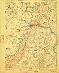
~ Harpers Ferry VA topo map, 1:125000 scale, 30 X 30 Minute, Historical, 1893, updated 1910
Harpers Ferry, Virginia, USGS topographic map dated 1893.
Includes geographic coordinates (latitude and longitude). This topographic map is suitable for hiking, camping, and exploring, or framing it as a wall map.
Printed on-demand using high resolution imagery, on heavy weight and acid free paper, or alternatively on a variety of synthetic materials.
Topos available on paper, Waterproof, Poly, or Tyvek. Usually shipping rolled, unless combined with other folded maps in one order.
- Product Number: USGS-5303910
- Free digital map download (high-resolution, GeoPDF): Harpers Ferry, Virginia (file size: 6 MB)
- Map Size: please refer to the dimensions of the GeoPDF map above
- Weight (paper map): ca. 55 grams
- Map Type: POD USGS Topographic Map
- Map Series: HTMC
- Map Verison: Historical
- Cell ID: 65645
- Scan ID: 188991
- Imprint Year: 1910
- Survey Year: 1884
- Datum: Unstated
- Map Projection: Unstated
- Map published by United States Geological Survey
- Map Language: English
- Scanner Resolution: 600 dpi
- Map Cell Name: Harpers Ferry
- Grid size: 30 X 30 Minute
- Date on map: 1893
- Map Scale: 1:125000
- Geographical region: Virginia, United States
Neighboring Maps:
All neighboring USGS topo maps are available for sale online at a variety of scales.
Spatial coverage:
Topo map Harpers Ferry, Virginia, covers the geographical area associated the following places:
- Sunset View - Paeonian Springs - Edinburg Forest - Jefferson Oaks - Welbourne - Duffields - Potomac Gateway - Canavest (historical) - Sycolin - Rock Hall - Briercrest Heights - Paris - Braddock Estates - Middletown Manor - Taylorstown - Petersville - Treadwell - Shrys Store - Middletown - Murphys Corner - Browns Corner - Ivandale - Bloomery - Corner House - Locust Grove - Randolph Corner - Berrys - Jamestown - Pleasantville - Pikeside - Powells Grove - Samples Manor - Little Washington - Stockman Estates - Ashby Run - Knoxville - Mill Creek - Furnace Mountain - Strawleigh - Ridge Crest Estates - Stonebraker (historical) - Battletown - Valley View Estates - EcoVillage of Loudoun County - Washington Junction - Homers Delight - Graves - Springview - Glenridge Estates - Olive - Bradbury Heights - Morningside - Bolivar - Remsberg Acres - Kabletown - Picnic Woods Estates - Crown Estates - Telegraph Spring - Bardane - Morrisonville - Rohrersville - Hillsboro - Leetown - Horse Shoe Bend - Brownsville - Potomac Crest - Walpers Cross-Roads - Blue Ridge Estates - Confederate Hills - Gapland - Harshman Estates - Locust Valley - Brownsville - Woodcrest - Bells Mill - Bidle Hill Acres - Wilson - Valley Overlook - Middletown Heights - Sharpsburg - Mannings - Hughesville - Lewis Mill - Care Free Acres - Scattersville - Meyerstown - Middlebrook - Douglas Grove - Skeetersville - Gambrill South - Fairview - Belmont - Frogtown - Trapp - Mountain Lake - West Middletown Estates - Milltown - Webbtown - Red Hill - Skyline Estates
- Map Area ID: AREA39.539-78-77.5
- Northwest corner Lat/Long code: USGSNW39.5-78
- Northeast corner Lat/Long code: USGSNE39.5-77.5
- Southwest corner Lat/Long code: USGSSW39-78
- Southeast corner Lat/Long code: USGSSE39-77.5
- Northern map edge Latitude: 39.5
- Southern map edge Latitude: 39
- Western map edge Longitude: -78
- Eastern map edge Longitude: -77.5


