
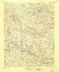
~ Goochland VA topo map, 1:125000 scale, 30 X 30 Minute, Historical, 1892, updated 1925
Goochland, Virginia, USGS topographic map dated 1892.
Includes geographic coordinates (latitude and longitude). This topographic map is suitable for hiking, camping, and exploring, or framing it as a wall map.
Printed on-demand using high resolution imagery, on heavy weight and acid free paper, or alternatively on a variety of synthetic materials.
Topos available on paper, Waterproof, Poly, or Tyvek. Usually shipping rolled, unless combined with other folded maps in one order.
- Product Number: USGS-5303882
- Free digital map download (high-resolution, GeoPDF): Goochland, Virginia (file size: 7 MB)
- Map Size: please refer to the dimensions of the GeoPDF map above
- Weight (paper map): ca. 55 grams
- Map Type: POD USGS Topographic Map
- Map Series: HTMC
- Map Verison: Historical
- Cell ID: 65577
- Scan ID: 188964
- Imprint Year: 1925
- Survey Year: 1888
- Datum: NAD
- Map Projection: Polyconic
- Map published by United States Geological Survey
- Map Language: English
- Scanner Resolution: 600 dpi
- Map Cell Name: Goochland
- Grid size: 30 X 30 Minute
- Date on map: 1892
- Map Scale: 1:125000
- Geographical region: Virginia, United States
Neighboring Maps:
All neighboring USGS topo maps are available for sale online at a variety of scales.
Spatial coverage:
Topo map Goochland, Virginia, covers the geographical area associated the following places:
- Huguenot Hills - Oxford - Crozier - Pinehurts - Westover Gardens - Apple Grove - Gays (historical) - Maidens - Partridge Hills - Huguenot Farms - Beaumont - Woods Acres - Perkinsville - Venice Heights - Gravel Hill - Childress - Countryside West - Lower Tuckahoe - Three Oaks - Huguenot Springs - Shelfar - Ramsgate - Trice Subdivision - Hickory Haven - Highland Hills - Hobby Hill Farms - Covington - Vinita - Chippenham Village - Greenes Corner - Vontay - Grand Summit - Pagebrook - Horsepen Hills - East Leake - Cedar Fork - Laurel - Worshams - Subletts - Spring Grove - Threemile Corner - Maidens Forest - Fair Woods - Boscobel - Houstons Corner - Oak Grove Estates - James River Estates - South Anna - Tinsleys - Three Square - Bumpass - Old Oaks - Pleasant Green - Wickham Corner - Westover Heights - Cedar Hills - Homewood Park - Woodmont - Poplar Forest - East Courthouse Estates - Goshen Cross Road - Goochland - Broad Meadows - Thorncliff - Wayland - Mount Olive Terrace - Dongola - Smokey Hollow - Buckingham - Mooreland - Robious - Green Bay - Southhampton Hills - Coatesville - Wingmead - Tuckahoe Village - Huntleigh - Bretton Woods - Tylers - Strawberry Run - Chilesburg - Coffey Corner - The Forest - Mooreland Farms - Locust Creek - Michaux - Southampton - Verdon - Sheffield Court - North Anna - Lee - Lone Oak - Wedgewood - Auburn Chase - Deerfield - Hadensville - Old Bandana - Manakin - Lilburn - Mabelton
- Map Area ID: AREA3837.5-78-77.5
- Northwest corner Lat/Long code: USGSNW38-78
- Northeast corner Lat/Long code: USGSNE38-77.5
- Southwest corner Lat/Long code: USGSSW37.5-78
- Southeast corner Lat/Long code: USGSSE37.5-77.5
- Northern map edge Latitude: 38
- Southern map edge Latitude: 37.5
- Western map edge Longitude: -78
- Eastern map edge Longitude: -77.5


