
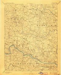
~ Goochland VA topo map, 1:125000 scale, 30 X 30 Minute, Historical, 1892, updated 1908
Goochland, Virginia, USGS topographic map dated 1892.
Includes geographic coordinates (latitude and longitude). This topographic map is suitable for hiking, camping, and exploring, or framing it as a wall map.
Printed on-demand using high resolution imagery, on heavy weight and acid free paper, or alternatively on a variety of synthetic materials.
Topos available on paper, Waterproof, Poly, or Tyvek. Usually shipping rolled, unless combined with other folded maps in one order.
- Product Number: USGS-5303878
- Free digital map download (high-resolution, GeoPDF): Goochland, Virginia (file size: 7 MB)
- Map Size: please refer to the dimensions of the GeoPDF map above
- Weight (paper map): ca. 55 grams
- Map Type: POD USGS Topographic Map
- Map Series: HTMC
- Map Verison: Historical
- Cell ID: 65577
- Scan ID: 188960
- Imprint Year: 1908
- Survey Year: 1888
- Datum: Unstated
- Map Projection: Unstated
- Map published by United States Geological Survey
- Map Language: English
- Scanner Resolution: 600 dpi
- Map Cell Name: Goochland
- Grid size: 30 X 30 Minute
- Date on map: 1892
- Map Scale: 1:125000
- Geographical region: Virginia, United States
Neighboring Maps:
All neighboring USGS topo maps are available for sale online at a variety of scales.
Spatial coverage:
Topo map Goochland, Virginia, covers the geographical area associated the following places:
- Provost - Mabelton - Smokey Hollow - Gayton - Terrell Store - Tylers - Lorraine - Oaklands - Tuckahoe Village - Brighton Green - Macon - Manakin Farms - Lone Oak - Bellview Gardens - Hermitage Hamlet - Goshen Cross Road - Woodmont - Covington - Gouldin - Plain View - Partridge Hills - Tally Ho Estates - Ziontown - Huntleigh - Staffordshire - Samary Forest - Maidens - Short Pump - Lee - Shelfar - Hewlett - Oilville - North Anna - Cambridge - Lake Killarney - Huguenot - Pembroke - Highland Hills - Mooreland - Jackson - Willowbrook - Running Still - Stratford Hills - Fine Creek Mills - Ramsgate - Oxford - Laurel Lakes - Windy Run - Perkinsville - Grand Summit - Horsepen Hills - Laurel Village - Beaufont Hills - Huguenot Farms - Ashwoods - South Anna - River Cliff - Holly Hills - Southhampton Hills - Laurel - Pittaway Farms - Farrington - Crestview - Westlake Hills - James River Estates - Wheatlands - Huguenot Hills - Sandy Hook - Granite - Golansville - Holiday Hills - Orchid - River Road Hills - Holly Grove - Deerwood - Johnsons Springs - Glen Allen - Wayland - Buckingham - Westham - Sabot - Gays (historical) - Nottingham - Hadensville Estates - Chippenham Village - Broad Meadows - Buckner - Scotchtown - Dover Run - Spring Grove - Robious - Deerfield - Threemile Corner - Fair Woods - Cherokee Hills - Teman - Subletts - Lower Tuckahoe - Bridlewood - Noel
- Map Area ID: AREA3837.5-78-77.5
- Northwest corner Lat/Long code: USGSNW38-78
- Northeast corner Lat/Long code: USGSNE38-77.5
- Southwest corner Lat/Long code: USGSSW37.5-78
- Southeast corner Lat/Long code: USGSSE37.5-77.5
- Northern map edge Latitude: 38
- Southern map edge Latitude: 37.5
- Western map edge Longitude: -78
- Eastern map edge Longitude: -77.5


