
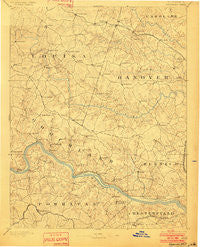
~ Goochland VA topo map, 1:125000 scale, 30 X 30 Minute, Historical, 1892, updated 1901
Goochland, Virginia, USGS topographic map dated 1892.
Includes geographic coordinates (latitude and longitude). This topographic map is suitable for hiking, camping, and exploring, or framing it as a wall map.
Printed on-demand using high resolution imagery, on heavy weight and acid free paper, or alternatively on a variety of synthetic materials.
Topos available on paper, Waterproof, Poly, or Tyvek. Usually shipping rolled, unless combined with other folded maps in one order.
- Product Number: USGS-5303876
- Free digital map download (high-resolution, GeoPDF): Goochland, Virginia (file size: 8 MB)
- Map Size: please refer to the dimensions of the GeoPDF map above
- Weight (paper map): ca. 55 grams
- Map Type: POD USGS Topographic Map
- Map Series: HTMC
- Map Verison: Historical
- Cell ID: 65577
- Scan ID: 188959
- Imprint Year: 1901
- Survey Year: 1888
- Datum: Unstated
- Map Projection: Unstated
- Map published by United States Geological Survey
- Map Language: English
- Scanner Resolution: 600 dpi
- Map Cell Name: Goochland
- Grid size: 30 X 30 Minute
- Date on map: 1892
- Map Scale: 1:125000
- Geographical region: Virginia, United States
Neighboring Maps:
All neighboring USGS topo maps are available for sale online at a variety of scales.
Spatial coverage:
Topo map Goochland, Virginia, covers the geographical area associated the following places:
- Auburn Chase - Johnsons Springs - Quioccasin - Beaufont Hills - Bellview Gardens - Amber Lake - Chelsea - Shady Grove - Lorraine - Goochland - Lee - Covington - Homewood Park - Othma - Vigor - Gayton - Golansville - Hillcrest - Horsepen Hills - Gouldin - Houstons Corner - Crosswoods West - Spring Grove - Hobby Hill Farms - Crestwood Farms - Stratford Hills - Canterbury - Woods Acres - Hewlett - Hadensville Estates - Teman - Duggins Store - Sycamore Creek - Pleasant Green - Chippenham Village - Westbriar - Glen Echo Place - Maidens Forest - Hickory Haven - Locust Creek - Jefferson (historical) - Poplar Forest - Huguenot Hills - Farrington - Wickham Corner - Laurel Lakes - Old Bandana - Tinsleys - Lanes Corner - Coffey Corner - Buckner - Dawnington Sabot - Rockville - Woodmont - Mayos Woods - Provost - Strawberry Run - Cuckoo - Dorset Woods - Cardwell - Ashwoods - West Jenningsville - Centerville - East Courthouse Estates - Oilville - Bon Air Manor - Holly Hills - Mooreland - Pagebrook - Pittaway Farms - Bon Air - Fernleigh - Wyndham - Venice Heights - Hadensville - Willowbrook - Willow Oaks - Perkinsville - Aldwyck - Smokey Hollow - Laurel Village - Brittland - Montpelier - Fine Creek Mills - Powhatan - Hadensville Farms - Cherokee Hills - Old Oaks - Brighton Green - Deerfield - Partridge Hills - Cedar Fork - River Road Hills - Longcreek (historical) - Scotchtown - Red Lane - Westchester - Ziontown - Countryside West - Lilburn
- Map Area ID: AREA3837.5-78-77.5
- Northwest corner Lat/Long code: USGSNW38-78
- Northeast corner Lat/Long code: USGSNE38-77.5
- Southwest corner Lat/Long code: USGSSW37.5-78
- Southeast corner Lat/Long code: USGSSE37.5-77.5
- Northern map edge Latitude: 38
- Southern map edge Latitude: 37.5
- Western map edge Longitude: -78
- Eastern map edge Longitude: -77.5


