
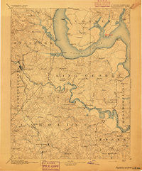
~ Fredericksburg VA topo map, 1:125000 scale, 30 X 30 Minute, Historical, 1894
Fredericksburg, Virginia, USGS topographic map dated 1894.
Includes geographic coordinates (latitude and longitude). This topographic map is suitable for hiking, camping, and exploring, or framing it as a wall map.
Printed on-demand using high resolution imagery, on heavy weight and acid free paper, or alternatively on a variety of synthetic materials.
Topos available on paper, Waterproof, Poly, or Tyvek. Usually shipping rolled, unless combined with other folded maps in one order.
- Product Number: USGS-5303850
- Free digital map download (high-resolution, GeoPDF): Fredericksburg, Virginia (file size: 8 MB)
- Map Size: please refer to the dimensions of the GeoPDF map above
- Weight (paper map): ca. 55 grams
- Map Type: POD USGS Topographic Map
- Map Series: HTMC
- Map Verison: Historical
- Cell ID: 65520
- Scan ID: 188943
- Survey Year: 1888
- Datum: Unstated
- Map Projection: Unstated
- Map published by United States Geological Survey
- Map Language: English
- Scanner Resolution: 600 dpi
- Map Cell Name: Fredericksburg
- Grid size: 30 X 30 Minute
- Date on map: 1894
- Map Scale: 1:125000
- Geographical region: Virginia, United States
Neighboring Maps:
All neighboring USGS topo maps are available for sale online at a variety of scales.
Spatial coverage:
Topo map Fredericksburg, Virginia, covers the geographical area associated the following places:
- Foreston Woods North - Moreland - Brookewood Farms - Vista Woods - Tetotum - J A Macgregor Estate - Highpointe - Onville (historical) - Fitzhugh - Hazel Hill - Kendallwood East - Brentland - Bayview Estates - Bexley Manor - Mattox Bridge - Marlboro - Lent - Argyle Terrace - Elizabeth Park - Kings Crest - Jacks Fork - Oakridge Overlook - Hampstead Village - Belvedere - Baylortown - Welcome Acres - Debruyn - Waltlou Mobile Home Park - The Hills of Stafford - Knotsmythes Landing - Glenwood Forest - Quarry Estates - Stones Corner - Grace Shelton Family Subdivision - Summerwood - Grayton - Milford - Potomac Run Farm - Whites (historical) - Apple Grove - Chestnut Hill - Featherstone Fork - Long Branch - North Potomac - Stuart Corner - Brooksmill Estates - Falmouth Bridge - Heritage Oaks - Park - Artillery Ridge - Daffan - Will Morgan Farm - O Bannon Land - Blaisdell Subdivision - Hooes - Maryland Point - Courts at Stafford - Comorn - Greenridge - Rixey - Aquia - High School Heights - Rappahannock Corner - Meadowlark - Little Falls Village - Acodale - Ironsides - Aquia Overlook - Poorhouse Corner - Cottage Green - Olde Forge - Smith Hill - Highland Homes - Victoria Woods - Belmont Hills - The Oaks at Ferry Farm - Boscobel Woods - Falmouth Village - Brookfield Hills - Kendallwood Estates - Aquia Creek - Freedom Estates - Taylors Corner - Bel Plains Estates - Country Ridge - Bowling Green - Subdivision Estates - Brooke Ridge - Eubank Corner - Sandy Ridge - Potomac Overlook - Cobblestone - Bel Air - Graves Corner - The Columns - Woodmont - Bethlehem Fork - Carters Store - Wrights Corner - Naulakla
- Map Area ID: AREA38.538-77.5-77
- Northwest corner Lat/Long code: USGSNW38.5-77.5
- Northeast corner Lat/Long code: USGSNE38.5-77
- Southwest corner Lat/Long code: USGSSW38-77.5
- Southeast corner Lat/Long code: USGSSE38-77
- Northern map edge Latitude: 38.5
- Southern map edge Latitude: 38
- Western map edge Longitude: -77.5
- Eastern map edge Longitude: -77


