
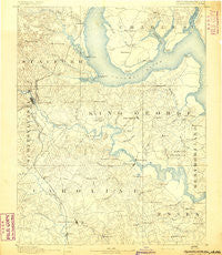
~ Fredericksburg VA topo map, 1:125000 scale, 30 X 30 Minute, Historical, 1892
Fredericksburg, Virginia, USGS topographic map dated 1892.
Includes geographic coordinates (latitude and longitude). This topographic map is suitable for hiking, camping, and exploring, or framing it as a wall map.
Printed on-demand using high resolution imagery, on heavy weight and acid free paper, or alternatively on a variety of synthetic materials.
Topos available on paper, Waterproof, Poly, or Tyvek. Usually shipping rolled, unless combined with other folded maps in one order.
- Product Number: USGS-5303848
- Free digital map download (high-resolution, GeoPDF): Fredericksburg, Virginia (file size: 6 MB)
- Map Size: please refer to the dimensions of the GeoPDF map above
- Weight (paper map): ca. 55 grams
- Map Type: POD USGS Topographic Map
- Map Series: HTMC
- Map Verison: Historical
- Cell ID: 65520
- Scan ID: 188941
- Survey Year: 1888
- Datum: Unstated
- Map Projection: Unstated
- Map published by United States Geological Survey
- Map Language: English
- Scanner Resolution: 600 dpi
- Map Cell Name: Fredericksburg
- Grid size: 30 X 30 Minute
- Date on map: 1892
- Map Scale: 1:125000
- Geographical region: Virginia, United States
Neighboring Maps:
All neighboring USGS topo maps are available for sale online at a variety of scales.
Spatial coverage:
Topo map Fredericksburg, Virginia, covers the geographical area associated the following places:
- Chatham Farms - Oakridge Overlook - Belle Oaks - Camden - Grayton - Courts at Stafford - East Argyle Heights - Marlboro - Rolling Meadows - Chatam - Port Aquia - Fredericksburg - Clearview Heights - Apple Grove - Friendship Acres - Cherry Hill Estates - Walter Roberson Estate - Daltons - Cedar Grove - Onville (historical) - Uly Brooks - Locklears Knoll - Olde Forge - Greenstreet Mobile Home Park - Fines Corner - Butzner Corner - Smith Lake Landing - Oakland and Fairview - Marshall Estates - Mount Pleasant - The Holly Woods - Saratoga - Canterbury Estates - The Falls - Grays Steven Tract - Stefin Woods Estate - Falmouth Village - Dickinsons Corner - Portobago - Huntington Hills - Park - The Oaks Mobile Home Park - Chelsea Estates - Windermere - Locks Corner - Belmont - Meadowood Park - East Chatham Heights - Mount Pleasant Estates - Confederate Ridge - Widewater Beach - Old Homestead - Beau Ridge - Quarry Estates - Aquia Harbour - Thorny Point Farm - Brookewood Farms - Magnolia Woods - Berthaville - Monroe Corner - Penn Manor - Concord Heights - New Hope Estates - Argyle Hills - Fourmile Fork - Battery Ridge Estates - Wellford Sullivan Estate - Raspberry - Colonial Terrace - Sandy Ridge - Brookfield - Cottage Green - Potomac Shores - Dogue - Stafford Heights - Woodlanding Village - Hustle - Fairview Beach - Hamilton Crossing - Vestavia Woods - Antioch Fork - Garrisonville Estates - Tetotum - Boscobel - Passapatanzy - Willamsburg on the Potomac - Leeland Station - Milbank - Nash Town - Victoria Woods - Lee's Hill Mobile Home Park - Graninger - Brooke - Ninde - Gayles - Hickory Fork - O Bannon Land - Bowers - Stones Corner - Eubank Corner
- Map Area ID: AREA38.538-77.5-77
- Northwest corner Lat/Long code: USGSNW38.5-77.5
- Northeast corner Lat/Long code: USGSNE38.5-77
- Southwest corner Lat/Long code: USGSSW38-77.5
- Southeast corner Lat/Long code: USGSSE38-77
- Northern map edge Latitude: 38.5
- Southern map edge Latitude: 38
- Western map edge Longitude: -77.5
- Eastern map edge Longitude: -77


