
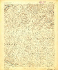
~ Appomattox VA topo map, 1:125000 scale, 30 X 30 Minute, Historical, 1892
Appomattox, Virginia, USGS topographic map dated 1892.
Includes geographic coordinates (latitude and longitude). This topographic map is suitable for hiking, camping, and exploring, or framing it as a wall map.
Printed on-demand using high resolution imagery, on heavy weight and acid free paper, or alternatively on a variety of synthetic materials.
Topos available on paper, Waterproof, Poly, or Tyvek. Usually shipping rolled, unless combined with other folded maps in one order.
- Product Number: USGS-5303736
- Free digital map download (high-resolution, GeoPDF): Appomattox, Virginia (file size: 7 MB)
- Map Size: please refer to the dimensions of the GeoPDF map above
- Weight (paper map): ca. 55 grams
- Map Type: POD USGS Topographic Map
- Map Series: HTMC
- Map Verison: Historical
- Cell ID: 64899
- Scan ID: 188846
- Survey Year: 1890
- Datum: Unstated
- Map Projection: Unstated
- Map published by United States Geological Survey
- Map Language: English
- Scanner Resolution: 600 dpi
- Map Cell Name: Appomattox
- Grid size: 30 X 30 Minute
- Date on map: 1892
- Map Scale: 1:125000
- Geographical region: Virginia, United States
Neighboring Maps:
All neighboring USGS topo maps are available for sale online at a variety of scales.
Spatial coverage:
Topo map Appomattox, Virginia, covers the geographical area associated the following places:
- Sherwill - Abell (historical) - Areanum - Toga - Elam - Phenix - Appomattox - Henry - Hat Creek - Cullen - Appomattox (historical) - Sugar Hill - Beckham - Rough Creek - Baileyville (historical) - Evergreen - Bowler - Chandlers Forks - Eureka - Prospect - Holts Crossing - Stapleton - Shields - Darlington Heights - Old Pilot (historical) - Tredway (historical) - Harrisburg - Brookneal - Chestnut Grove - Pamplin - Spout Spring - Aspen - Stonewall Mills - County Line Cross Roads - Mineral (historical) - Wren - Enonville - Charlotte Court House - Sliders - Hurtsville - Perth - Chap - Patrick Henry - Madisonville - Forbes (historical) - Flood - Terryville - Womacks - Hixburg - Fears Corner - Taro - Hollywood - Spring Mills - Abilene - Vera - Concord - Oakville - North Halifax - Aspenwall - Allens Mill - Stonewall - Martins Store - Andersonville - Vincent Corner - Five Forks - Fore Store
- Map Area ID: AREA37.537-79-78.5
- Northwest corner Lat/Long code: USGSNW37.5-79
- Northeast corner Lat/Long code: USGSNE37.5-78.5
- Southwest corner Lat/Long code: USGSSW37-79
- Southeast corner Lat/Long code: USGSSE37-78.5
- Northern map edge Latitude: 37.5
- Southern map edge Latitude: 37
- Western map edge Longitude: -79
- Eastern map edge Longitude: -78.5


