
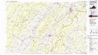
~ Front Royal VA topo map, 1:100000 scale, 30 X 60 Minute, Historical, 1986, updated 1986
Front Royal, Virginia, USGS topographic map dated 1986.
Includes geographic coordinates (latitude and longitude). This topographic map is suitable for hiking, camping, and exploring, or framing it as a wall map.
Printed on-demand using high resolution imagery, on heavy weight and acid free paper, or alternatively on a variety of synthetic materials.
Topos available on paper, Waterproof, Poly, or Tyvek. Usually shipping rolled, unless combined with other folded maps in one order.
- Product Number: USGS-5303648
- Free digital map download (high-resolution, GeoPDF): Front Royal, Virginia (file size: 15 MB)
- Map Size: please refer to the dimensions of the GeoPDF map above
- Weight (paper map): ca. 55 grams
- Map Type: POD USGS Topographic Map
- Map Series: HTMC
- Map Verison: Historical
- Cell ID: 67553
- Scan ID: 188786
- Imprint Year: 1986
- Woodland Tint: Yes
- Aerial Photo Year: 1984
- Edit Year: 1986
- Datum: NAD27
- Map Projection: Universal Transverse Mercator
- Planimetric: Yes
- Map published by United States Geological Survey
- Map Language: English
- Scanner Resolution: 600 dpi
- Map Cell Name: Front Royal
- Grid size: 30 X 60 Minute
- Date on map: 1986
- Map Scale: 1:100000
- Geographical region: Virginia, United States
Neighboring Maps:
All neighboring USGS topo maps are available for sale online at a variety of scales.
Spatial coverage:
Topo map Front Royal, Virginia, covers the geographical area associated the following places:
- Chester Gap - Vaughn - Revercombs Corner - Cavetown - Happy Creek - Slate Mills - Dilbeck - Mount Airy - Big Meadows - Big Spring - Sea Lock - West Lakes - Boston - Marksville - Huntly - Carmel - Success - Hilldale - Tunis - Readus - Highland Park - Morning Star - Intersections - Belle Meade - Downing (historical) - Harrisville - Jerome - Rediviva - Petersburg - Westlu - Valleyburgh - Woodville - Overall - Detrick - Nethers - Mechanicsville - Harrell Corner - Williamsville - Woodland Park - Shenandoah Farms - Glen Echo - Yankeetown - Hamburg - Linden Heights - Leaksville - Hensel Stone Woods - Lacey Spring - Riverside - Bergton - Columbia Furnace - Wakemans Grove - Monterey Orchards - Royal Village - Shenandoah Caverns - Front Royal - Cherry Grove - Sans Facon - Mauck - Seven Fountains - Oldrag - Colonial Park - Perry - Luray - Oldrag (historical) - Viewtown - Oakwood - Browntown - Chesterfield Estates - Mount Jackson - Catherine Furnace - Green Mount - Calvary - Castleton - Toms Brook - Palos - Arco - Monumental Mills - Deer Haven - Markham - Springfield - Massanova - Apple Mountain Lake - Skyland Estates - The Lions Den - Shavertown - Griffinsburg - Eggbornsville - Apple Mountain Lake West - Oak Hill - Hawkinstown - Hamburg - Turleytown - Hudson Crossroads - Van Buren Furnace - Quicksburg - Stultz Mill - Strasburg - Kerrington - Keysville - Rockland
- Map Area ID: AREA3938.5-79-78
- Northwest corner Lat/Long code: USGSNW39-79
- Northeast corner Lat/Long code: USGSNE39-78
- Southwest corner Lat/Long code: USGSSW38.5-79
- Southeast corner Lat/Long code: USGSSE38.5-78
- Northern map edge Latitude: 39
- Southern map edge Latitude: 38.5
- Western map edge Longitude: -79
- Eastern map edge Longitude: -78


