
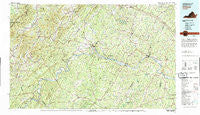
~ Dillwyn VA topo map, 1:100000 scale, 30 X 60 Minute, Historical, 1979, updated 1982
Dillwyn, Virginia, USGS topographic map dated 1979.
Includes geographic coordinates (latitude and longitude). This topographic map is suitable for hiking, camping, and exploring, or framing it as a wall map.
Printed on-demand using high resolution imagery, on heavy weight and acid free paper, or alternatively on a variety of synthetic materials.
Topos available on paper, Waterproof, Poly, or Tyvek. Usually shipping rolled, unless combined with other folded maps in one order.
- Product Number: USGS-5303638
- Free digital map download (high-resolution, GeoPDF): Dillwyn, Virginia (file size: 26 MB)
- Map Size: please refer to the dimensions of the GeoPDF map above
- Weight (paper map): ca. 55 grams
- Map Type: POD USGS Topographic Map
- Map Series: HTMC
- Map Verison: Historical
- Cell ID: 67422
- Scan ID: 188781
- Imprint Year: 1982
- Woodland Tint: Yes
- Aerial Photo Year: 1977
- Edit Year: 1979
- Datum: NAD27
- Map Projection: Universal Transverse Mercator
- Map published by United States Geological Survey
- Map Language: English
- Scanner Resolution: 600 dpi
- Map Cell Name: Dillwyn
- Grid size: 30 X 60 Minute
- Date on map: 1979
- Map Scale: 1:100000
- Geographical region: Virginia, United States
Neighboring Maps:
All neighboring USGS topo maps are available for sale online at a variety of scales.
Spatial coverage:
Topo map Dillwyn, Virginia, covers the geographical area associated the following places:
- Scottsville - Trenton Mills - Stokes (historical) - Kidds Store - Gladstone - Buckingham - Crossroads - Roseland - Simeon - Wildwood - Powell Corner - Dixie - Chimney Springs - Mill Creek - Gravel Hill - Rockfish - Bells Crossroads - Columbia - Five Forks - Elma - Allenslevel - Lodebar - Hardware - Sunny Side - Nuckols - Pemberton - Sprouses Corner - Bula - Tapscott - Wintergreen - LeSueur - Old Myndus - McCullough - Boiling Spring - Hunters - North Garden - Overton - Running Deer - Riverville - Saint Joy - Old Dominion - Trenholm - Redland - Eldridge Corner - Tamworth - Grays Corner - Schuyler - Carysbrook - Centenary - Byrd Mill - Cremona (historical) - Arrington - Arvonia - Rasawek (historical) - Rockaway - Palmyra - Alberene - Faber - Greenway - Katrine - Smiths Crossroads - Piedmont - Cunningham - Rosney - Manteo - Stony Point - Holmhead - Stage Junction - Dentons Corner - Gordon Crossing - Durrett Town - Shannon Hill - Norwood - Lake Monticello - Bridgeport - Hamilton - Blenheim - Valmont Estates - Bush Park (historical) - Paynes Mill - Hatchers - Sherando - Woodridge - Shipman - Mount Rush - Lawthorne Mill - Old Mount Vinco - Enon - Cohasset - Belona - Hunters Trail - Stearnes - Tillmans - Lovingston - Adial - Nicholas - New Mount Vinco - Keene - Hendersons Store - Beech Grove
- Map Area ID: AREA3837.5-79-78
- Northwest corner Lat/Long code: USGSNW38-79
- Northeast corner Lat/Long code: USGSNE38-78
- Southwest corner Lat/Long code: USGSSW37.5-79
- Southeast corner Lat/Long code: USGSSE37.5-78
- Northern map edge Latitude: 38
- Southern map edge Latitude: 37.5
- Western map edge Longitude: -79
- Eastern map edge Longitude: -78


