
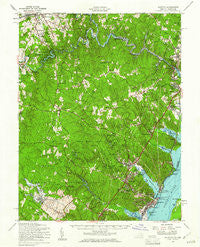
~ Quantico VA topo map, 1:62500 scale, 15 X 15 Minute, Historical, 1957, updated 1961
Quantico, Virginia, USGS topographic map dated 1957.
Includes geographic coordinates (latitude and longitude). This topographic map is suitable for hiking, camping, and exploring, or framing it as a wall map.
Printed on-demand using high resolution imagery, on heavy weight and acid free paper, or alternatively on a variety of synthetic materials.
Topos available on paper, Waterproof, Poly, or Tyvek. Usually shipping rolled, unless combined with other folded maps in one order.
- Product Number: USGS-5303306
- Free digital map download (high-resolution, GeoPDF): Quantico, Virginia (file size: 10 MB)
- Map Size: please refer to the dimensions of the GeoPDF map above
- Weight (paper map): ca. 55 grams
- Map Type: POD USGS Topographic Map
- Map Series: HTMC
- Map Verison: Historical
- Cell ID: 61377
- Scan ID: 188507
- Imprint Year: 1961
- Woodland Tint: Yes
- Aerial Photo Year: 1955
- Field Check Year: 1957
- Datum: NAD27
- Map Projection: Polyconic
- Map published by United States Army Corps of Engineers
- Map Language: English
- Scanner Resolution: 600 dpi
- Map Cell Name: Quantico
- Grid size: 15 X 15 Minute
- Date on map: 1957
- Map Scale: 1:62500
- Geographical region: Virginia, United States
Neighboring Maps:
All neighboring USGS topo maps are available for sale online at a variety of scales.
Spatial coverage:
Topo map Quantico, Virginia, covers the geographical area associated the following places:
- Occoquan - Potomac Mills - Rippon Landing - Johnson Woods - Ridgedale - Shenandoah - Occoquan River Hills - Barksdale - Neabsco Hills - Georgetown South - Woodlawn Meadows - Raintree - Tripoli Heights - Krukrak (historical) - Valley Vue - Brentsville - Hunters Square - Hillendale - Windy Hill - Glendale - Woodlea - Dale City - Princedale - Cornwell - Meadowbrook - Bradley Forest - Marumsco Acres - Fair Estates - Camelot - Kerrydale - Combat Village - Joplin - Grayson Village Mobile Home Park - Hunters Grove Estates - Lake Jackson - Forest Park Mobile Home Village - Blandsford - Fostern Estates - Belfair Crossroads - Colony Woods - Oaks of Shenandoah - Walton - Laurel Hills - Longview - Graham Park Shores - Vernon Estates - Chopawamsic (historical) - Montyville - Woodbine - Woodbine Forest - Lake Ridge - Montclair - Azalea Mobile Home Park - Bethel - Ravenwood - Dumfries - Bloom Hill - Montyville Estates - Terrapin Forest - Limstrong - Bel Air Mobile Home Park - Lorfax Heights - Oak Hill Estates - Oak Hill Farms - Featherstone - Chevalle - Quantico - Lake Occoquan Shores - Marumsco Woods - Marumsco Village - Kimberly Knolls - Mapledale - Cloverdale - Westchester - Mavel Manor - Foxridge - Walmsley (historical) - Hillside Terrace - Wooded Acres - Woodhaven - Deerfield - Silverdale - Lyman Park - Farrs Corner - Occoquan Forest - Riverview Estates - Featherstone Mobile Home Park - Orangedale - Country Roads - Champ Mills Estates - Rose Hill - Marumsco Hills - Hoadly - Garrisons Corners (historical) - Tall Trees Estates - Independent Hill - Mockingbird Ridge - Canova - Old Belle Fair (historical) - Cherry Hill
- Map Area ID: AREA38.7538.5-77.5-77.25
- Northwest corner Lat/Long code: USGSNW38.75-77.5
- Northeast corner Lat/Long code: USGSNE38.75-77.25
- Southwest corner Lat/Long code: USGSSW38.5-77.5
- Southeast corner Lat/Long code: USGSSE38.5-77.25
- Northern map edge Latitude: 38.75
- Southern map edge Latitude: 38.5
- Western map edge Longitude: -77.5
- Eastern map edge Longitude: -77.25


