
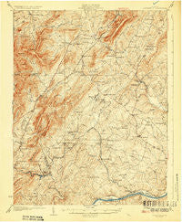
~ Covesville VA topo map, 1:62500 scale, 15 X 15 Minute, Historical, 1929
Covesville, Virginia, USGS topographic map dated 1929.
Includes geographic coordinates (latitude and longitude). This topographic map is suitable for hiking, camping, and exploring, or framing it as a wall map.
Printed on-demand using high resolution imagery, on heavy weight and acid free paper, or alternatively on a variety of synthetic materials.
Topos available on paper, Waterproof, Poly, or Tyvek. Usually shipping rolled, unless combined with other folded maps in one order.
- Product Number: USGS-5302760
- Free digital map download (high-resolution, GeoPDF): Covesville, Virginia (file size: 9 MB)
- Map Size: please refer to the dimensions of the GeoPDF map above
- Weight (paper map): ca. 55 grams
- Map Type: POD USGS Topographic Map
- Map Series: HTMC
- Map Verison: Historical
- Cell ID: 53005
- Scan ID: 188003
- Survey Year: 1926
- Datum: NAD
- Map Projection: Polyconic
- Map published by United States Geological Survey
- Map Language: English
- Scanner Resolution: 600 dpi
- Map Cell Name: Covesville
- Grid size: 15 X 15 Minute
- Date on map: 1929
- Map Scale: 1:62500
- Geographical region: Virginia, United States
Neighboring Maps:
All neighboring USGS topo maps are available for sale online at a variety of scales.
Spatial coverage:
Topo map Covesville, Virginia, covers the geographical area associated the following places:
- Tapscott - Old Dominion - Miran Forest - Faber - Crossroads - Bungletown - Alberene - Batesville - McCullough - Totier Hills - Boiling Spring - Glendower - Covesville - Brownton (historical) - Valmont Estates - Southwood Estates Mobile Home Park - Damon - North Garden - Mill Creek - Marshall Manor - Esmont - Redland - Warren - Hatton - Tillmans - Browntown - Porters - Schuyler - Keene - Powell Corner - Arrowhead
- Map Area ID: AREA3837.75-78.75-78.5
- Northwest corner Lat/Long code: USGSNW38-78.75
- Northeast corner Lat/Long code: USGSNE38-78.5
- Southwest corner Lat/Long code: USGSSW37.75-78.75
- Southeast corner Lat/Long code: USGSSE37.75-78.5
- Northern map edge Latitude: 38
- Southern map edge Latitude: 37.75
- Western map edge Longitude: -78.75
- Eastern map edge Longitude: -78.5


