
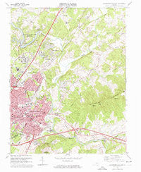
~ Charlottesville East VA topo map, 1:24000 scale, 7.5 X 7.5 Minute, Historical, 1973, updated 1974
Charlottesville East, Virginia, USGS topographic map dated 1973.
Includes geographic coordinates (latitude and longitude). This topographic map is suitable for hiking, camping, and exploring, or framing it as a wall map.
Printed on-demand using high resolution imagery, on heavy weight and acid free paper, or alternatively on a variety of synthetic materials.
Topos available on paper, Waterproof, Poly, or Tyvek. Usually shipping rolled, unless combined with other folded maps in one order.
- Product Number: USGS-5297102
- Free digital map download (high-resolution, GeoPDF): Charlottesville East, Virginia (file size: 13 MB)
- Map Size: please refer to the dimensions of the GeoPDF map above
- Weight (paper map): ca. 55 grams
- Map Type: POD USGS Topographic Map
- Map Series: HTMC
- Map Verison: Historical
- Cell ID: 8231
- Scan ID: 184427
- Imprint Year: 1974
- Woodland Tint: Yes
- Aerial Photo Year: 1972
- Field Check Year: 1973
- Datum: NAD27
- Map Projection: Polyconic
- Map published by United States Geological Survey
- Map Language: English
- Scanner Resolution: 600 dpi
- Map Cell Name: Charlottesville East
- Grid size: 7.5 X 7.5 Minute
- Date on map: 1973
- Map Scale: 1:24000
- Geographical region: Virginia, United States
Neighboring Maps:
All neighboring USGS topo maps are available for sale online at a variety of scales.
Spatial coverage:
Topo map Charlottesville East, Virginia, covers the geographical area associated the following places:
- Hunters Hall - Woodbrook - Westmoreland - Westgate - Berkmar - Westfield - Ashcroft - Glenorchy - Lake Hills - Village Square - Windsor - Belmont - Templeton Acres - West View Terrace - Greenbriar Heights - Shadwell - Berkeley - Shadwell Mountain - Barterbrook - Rivanna - Willoughby - Chapel Hills - Lochridge - Franklin - Monacan Town (historical) - Charlottesville - Northerly - Sleepy Hollow Mobile Home Park - Rio Heights - Clover Hill - Wildwood - Rio - Ardwood - Hydraulic - Hollymead - Carrsbrook - Bell Haven - Monasukapanough (historical) - Branchland - Riverrun - Little Clover Hill - Birnam Wood - Eastham - Pantops - Stonehenge - Locust Grove - Glenmore - Proffit - Four Seasons - Greenfields - Rockbrook - Ridgewood Mobile Home Park - Raintree - Vinegar Hill - Northfields - The Meadows - Dunlora Plantation - Woolen Mills - Royal Acres - Key West - Commonwealth - Bedford Hills - Milton Heights - Townwood - Bentivar - Squire Hill - Pen Park - Shadwell Estates - Fieldbrook - Milton - Wakefield - Camellia Garden - Oak Terrace - Willow Heights
- Map Area ID: AREA38.12538-78.5-78.375
- Northwest corner Lat/Long code: USGSNW38.125-78.5
- Northeast corner Lat/Long code: USGSNE38.125-78.375
- Southwest corner Lat/Long code: USGSSW38-78.5
- Southeast corner Lat/Long code: USGSSE38-78.375
- Northern map edge Latitude: 38.125
- Southern map edge Latitude: 38
- Western map edge Longitude: -78.5
- Eastern map edge Longitude: -78.375


