
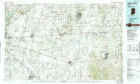
~ New Castle IN topo map, 1:100000 scale, 30 X 60 Minute, Historical, 1986, updated 1990
New Castle, Indiana, USGS topographic map dated 1986.
Includes geographic coordinates (latitude and longitude). This topographic map is suitable for hiking, camping, and exploring, or framing it as a wall map.
Printed on-demand using high resolution imagery, on heavy weight and acid free paper, or alternatively on a variety of synthetic materials.
Topos available on paper, Waterproof, Poly, or Tyvek. Usually shipping rolled, unless combined with other folded maps in one order.
- Product Number: USGS-5289186
- Free digital map download (high-resolution, GeoPDF): New Castle, Indiana (file size: 20 MB)
- Map Size: please refer to the dimensions of the GeoPDF map above
- Weight (paper map): ca. 55 grams
- Map Type: POD USGS Topographic Map
- Map Series: HTMC
- Map Verison: Historical
- Cell ID: 68040
- Scan ID: 159313
- Imprint Year: 1990
- Woodland Tint: Yes
- Photo Inspection Year: 1987
- Aerial Photo Year: 1984
- Edit Year: 1986
- Datum: NAD27
- Map Projection: Universal Transverse Mercator
- Map published by United States Geological Survey
- Map Language: English
- Scanner Resolution: 600 dpi
- Map Cell Name: New Castle
- Grid size: 30 X 60 Minute
- Date on map: 1986
- Map Scale: 1:100000
- Geographical region: Indiana, United States
Neighboring Maps:
All neighboring USGS topo maps are available for sale online at a variety of scales.
Spatial coverage:
Topo map New Castle, Indiana, covers the geographical area associated the following places:
- Kennard - Acton - Pinhook - Corwin - Bradford Court - Julietta - Columbia - Heather Point - New Castle - Philomath - Raleigh - Jacksonburg - Carriage Estates - Charlesmac Village - Dublin - Tremont - Sandstone Ridge - Blue Ridge - Knightstown - Alquina - Meiks - Chestnut Hill - Sun Down - London - Markleville - Chateau Court - Charlottesville - Van Nuys - Carefree Estates - The Portage - Philadelphia - Geist Woods - Highland Springs - Schildmeier Park - Carthage - Henry - Bowman Acres - Falmouth - Stringtown - Cleveland - Wilkinson - Brooks - Straughn - The Red Mills - Mohawk - Sterling Green - Idlewold - Belle Arbor - Forest Knoll - Cadiz - Lewisville - Walnut Hills - Crestmoor - Freeport - Westland - Hawthorn Hills - Henderson - Maplewood Mobile Home Park - Woodville - Mount Lawn - Sexton - Spring Lake - Foley - Manilla - Masthead - Economy - Springersville - New Salem - Harrisburg - Shelbyville - Hagerstown - Morristown - Blooming Grove - Brooks Crossing - College Corner - Raysville - Woodbury - Lakeside Green - Brownsville - Pleasant View - Fortville - Spiceland - Sugar Creek - Franklin - Milners Corner - Pierson Station - New Lisbon - Fall Creek Highland - Sand Creek Woods - Nulltown - Sweetbriar - Clover Village - Colonial Village - Collingwood - Warren Hills - McCordsville - Brookfield - Millville - Homer - Huber
- Map Area ID: AREA4039.5-86-85
- Northwest corner Lat/Long code: USGSNW40-86
- Northeast corner Lat/Long code: USGSNE40-85
- Southwest corner Lat/Long code: USGSSW39.5-86
- Southeast corner Lat/Long code: USGSSE39.5-85
- Northern map edge Latitude: 40
- Southern map edge Latitude: 39.5
- Western map edge Longitude: -86
- Eastern map edge Longitude: -85


