
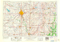
~ Wichita KS topo map, 1:250000 scale, 1 X 2 Degree, Historical, 1955, updated 1967
Wichita, Kansas, USGS topographic map dated 1955.
Includes geographic coordinates (latitude and longitude). This topographic map is suitable for hiking, camping, and exploring, or framing it as a wall map.
Printed on-demand using high resolution imagery, on heavy weight and acid free paper, or alternatively on a variety of synthetic materials.
Topos available on paper, Waterproof, Poly, or Tyvek. Usually shipping rolled, unless combined with other folded maps in one order.
- Product Number: USGS-5278188
- Free digital map download (high-resolution, GeoPDF): Wichita, Kansas (file size: 11 MB)
- Map Size: please refer to the dimensions of the GeoPDF map above
- Weight (paper map): ca. 55 grams
- Map Type: POD USGS Topographic Map
- Map Series: HTMC
- Map Verison: Historical
- Cell ID: 69097
- Scan ID: 707689
- Imprint Year: 1967
- Woodland Tint: Yes
- Aerial Photo Year: 1939
- Edit Year: 1966
- Datum: Unstated
- Map Projection: Transverse Mercator
- Map published by United States Geological Survey
- Map Language: English
- Scanner Resolution: 508 dpi
- Map Cell Name: Wichita
- Grid size: 1 X 2 Degree
- Date on map: 1955
- Map Scale: 1:250000
- Geographical region: Kansas, United States
Neighboring Maps:
All neighboring USGS topo maps are available for sale online at a variety of scales.
Spatial coverage:
Topo map Wichita, Kansas, covers the geographical area associated the following places:
- Aikman - Maple City - Fall River - Piedmont - Grafton - Wichita Heights - Midland Tower - South Haven - Furley - Vanora - Augusta Mobile Home Park - Prairie Hills Mobile Home Park - Fiat - Grand Summit - Meadowview - Mathis Mobile Home Park - Clearwater - Ewell - Saint Marks - Caudill Mobile Home Park - De Graff - Pine Ridge Manufactured Housing Community - Riverdale - Bluff City - Highpoint Mobile Home Park - Coleman - Mount Hope - Corbin - Township Mobile Home Park - Hopkins - Potwin - Zyba - Floral - Anness - Portland - Eastborough - Monett - Metcalf - Mulvane - Wauneta - Kechi - Patterson - Waterloo - Oak Court Mobile Home Court - Bloomington - Sunset Acres - Stroud Mobile Home Park - Towanda - Cloverdale - Danville - Whitman - Lamplighter Mobile Home Park - Forest Hills - Eaton - Bonnie Brae - Tyler - Reece - Cave Springs - Eschs (historical) - Prospect - Colwich - Connell - Oaklawn - Lorena - Cambridge - Arthur Heights - Rose Hill - Oakwood Manor Mobile Home Park - Summit - Wego-Waco - Rolling Hills - Conestoga Mobile Home Park - Deer Lake Mobile Home Estates - S and L Mobile Home Park - Twin Oaks Estates Mobile Home Park - Silverdale - Mona Kay Heights - Sunset Park - Hewins - Park Place Mobile Home Park - Reds Mobile Home Park - New Salem - Valley Mobile Home Park - Whitewater - Prospect Park - Pleasant Valley (historical) - Reynolds Mobile Home Park - Cedar Ridge Mobile Home Park - Hackney - Chelsea - Dahna Mobile Home Park - Wilson Manufactured Home Park - Rolling Meadows Mobile Home Park - Kamar Parkette Trailer Park - Virgil - Midway - Sunview Mobile Home Park - Kuhns Mobile Home Park - Country Acres Mobile Home Park - Lifestyle Mobile Home Park
- Map Area ID: AREA3837-98-96
- Northwest corner Lat/Long code: USGSNW38-98
- Northeast corner Lat/Long code: USGSNE38-96
- Southwest corner Lat/Long code: USGSSW37-98
- Southeast corner Lat/Long code: USGSSE37-96
- Northern map edge Latitude: 38
- Southern map edge Latitude: 37
- Western map edge Longitude: -98
- Eastern map edge Longitude: -96


