
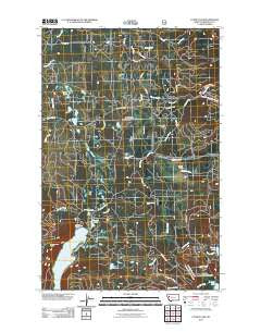
~ Cygnet Lake MT topo map, 1:24000 scale, 7.5 X 7.5 Minute, Historical, 2011
Cygnet Lake, Montana, USGS topographic map dated 2011.
Includes geographic coordinates (latitude and longitude). This topographic map is suitable for hiking, camping, and exploring, or framing it as a wall map.
Printed on-demand using high resolution imagery, on heavy weight and acid free paper, or alternatively on a variety of synthetic materials.
Topos available on paper, Waterproof, Poly, or Tyvek. Usually shipping rolled, unless combined with other folded maps in one order.
- Product Number: USGS-5271582
- Free digital map download (high-resolution, GeoPDF): Cygnet Lake, Montana (file size: 17 MB)
- Map Size: please refer to the dimensions of the GeoPDF map above
- Weight (paper map): ca. 55 grams
- Map Type: POD USGS Topographic Map
- Map Series: US Topo
- Map Verison: Historical
- Cell ID: 11144
- Datum: North American Datum of 1983
- Map Projection: Transverse Mercator
- Map Cell Name: Cygnet Lake
- Grid size: 7.5 X 7.5 Minute
- Date on map: 2011
- Map Scale: 1:24000
- Geographical region: Montana, United States
Neighboring Maps:
All neighboring USGS topo maps are available for sale online at a variety of scales.
Spatial coverage:
Topo map Cygnet Lake, Montana, covers the geographical area associated the following places:
- 20N16W20CCCB01 Well - Hultman 33 Ranch - Kraft Creek - Stoner Lake - Lindbergh Campground - Buck Creek - Pierce Lake - 19N16W05ABCC01 Well - Pierce Creek - Windfall Creek - 19N16W05ABCC02 Well - 19N16W06BDBA01 Well - Elbow Lookout Tower - Beaver Creek - 20N16W32ABCA01 Well - Loon Lake - South Fork Barber Creek - Swan Valley School - Barber Creek - Lairds (historical) - Gordon Ranch - 20N17W36BAAA01 Well - Summit Lake - 19N16W21ABAB01 Well - 20N16W32BCDA01 Well - 19N16W21AADA01 Well - 20N16W18DCDB01 Well - Lindbergh Lake - 20N16W29BCBB01 Well - Cygnet Lake - 20N17W36BAAB01 Well - 19N16W21ABC_01 Well - Holland Creek - 20N16W20BCCB01 Well - 19N16W07DBDD01 Well
- Map Area ID: AREA47.547.375-113.75-113.625
- Northwest corner Lat/Long code: USGSNW47.5-113.75
- Northeast corner Lat/Long code: USGSNE47.5-113.625
- Southwest corner Lat/Long code: USGSSW47.375-113.75
- Southeast corner Lat/Long code: USGSSE47.375-113.625
- Northern map edge Latitude: 47.5
- Southern map edge Latitude: 47.375
- Western map edge Longitude: -113.75
- Eastern map edge Longitude: -113.625


