
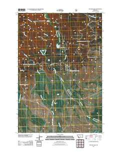
~ Pintler Lake MT topo map, 1:24000 scale, 7.5 X 7.5 Minute, Historical, 2011
Pintler Lake, Montana, USGS topographic map dated 2011.
Includes geographic coordinates (latitude and longitude). This topographic map is suitable for hiking, camping, and exploring, or framing it as a wall map.
Printed on-demand using high resolution imagery, on heavy weight and acid free paper, or alternatively on a variety of synthetic materials.
Topos available on paper, Waterproof, Poly, or Tyvek. Usually shipping rolled, unless combined with other folded maps in one order.
- Product Number: USGS-5266966
- Free digital map download (high-resolution, GeoPDF): Pintler Lake, Montana (file size: 17 MB)
- Map Size: please refer to the dimensions of the GeoPDF map above
- Weight (paper map): ca. 55 grams
- Map Type: POD USGS Topographic Map
- Map Series: US Topo
- Map Verison: Historical
- Cell ID: 35392
- Datum: North American Datum of 1983
- Map Projection: Transverse Mercator
- Map Cell Name: Pintler Lake
- Grid size: 7.5 X 7.5 Minute
- Date on map: 2011
- Map Scale: 1:24000
- Geographical region: Montana, United States
Neighboring Maps:
All neighboring USGS topo maps are available for sale online at a variety of scales.
Spatial coverage:
Topo map Pintler Lake, Montana, covers the geographical area associated the following places:
- 01S15W02ADAC01 Well - 01S15W04DACC01 Well - Big Bushong Ditch - Dreise Ranch - 01N15W34DADC01 Well - Pintler Falls - Christensen Ranch - 01S15W03BCBA01 Well - 01N15W14BCAA01 Well - Pintler Meadows - Lion Lake - West Fork Mudd Creek - East Fork Mudd Creek - Bowen Post Office (historical) - 01S15W03BBCD01 Well - East Fork Thompson Creek - Pintler Campground - L Bacon Ranch - Roberts Creek - 01S15W08BADD01 Well - Pintler Lake - 01N15W34DDAB02 Well - 01N15W34DDAB01 Well - Christenson Ditch - Nyhart Ditch - Bowen School (historical) - 01S15W03BCBA02 Well - McCormick Park - McCormick Creek - Sparrow Waste Ditch
- Map Area ID: AREA45.87545.75-113.5-113.375
- Northwest corner Lat/Long code: USGSNW45.875-113.5
- Northeast corner Lat/Long code: USGSNE45.875-113.375
- Southwest corner Lat/Long code: USGSSW45.75-113.5
- Southeast corner Lat/Long code: USGSSE45.75-113.375
- Northern map edge Latitude: 45.875
- Southern map edge Latitude: 45.75
- Western map edge Longitude: -113.5
- Eastern map edge Longitude: -113.375


