
~ Godfrey Peak NM topo map, 1:24000 scale, 7.5 X 7.5 Minute, Historical, 2011
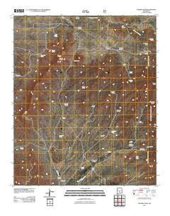
Godfrey Peak, New Mexico, USGS topographic map dated 2011.
Includes geographic coordinates (latitude and longitude). This topographic map is suitable for hiking, camping, and exploring, or framing it as a wall map.
Printed on-demand using high resolution imagery, on heavy weight and acid free paper, or alternatively on a variety of synthetic materials.
Topos available on paper, Waterproof, Poly, or Tyvek. Usually shipping rolled, unless combined with other folded maps in one order.
- Product Number: USGS-5245659
- Free digital map download (high-resolution, GeoPDF): Godfrey Peak, New Mexico (file size: 24 MB)
- Map Size: please refer to the dimensions of the GeoPDF map above
- Weight (paper map): ca. 55 grams
- Map Type: POD USGS Topographic Map
- Map Series: US Topo
- Map Verison: Historical
- Cell ID: 17561
- Datum: North American Datum of 1983
- Map Projection: Transverse Mercator
- Map Cell Name: Godfrey Peak
- Grid size: 7.5 X 7.5 Minute
- Date on map: 2011
- Map Scale: 1:24000
- Geographical region: New Mexico, United States
Neighboring Maps:
All neighboring USGS topo maps are available for sale online at a variety of scales.
Spatial coverage:
Topo map Godfrey Peak, New Mexico, covers the geographical area associated the following places:
- Barber Ridge - Robinson Spring - Padilla Spring - Lincoln Canyon - Lincoln Spring - Crawford Canyon - Mc Iver Canyon - Candelaria Spring - Elder Canyon - Candelaria Canyon - Crawford Well - Brownfield Spring - Winston Spring - Maverick Spring - North Windmill - Twin Wells Windmill - Winston Canyon - Tanner Spring - Walker Windmill - New Brownfield Well - Rock House Spring - Godfrey Peak - I-X Ranch - Trinidad Spring - Snaggletooth Well - Bataan Lodge - Cottonwood Spring - Tramble Windmill - Godfrey Hills - Bessie Case Spring - Snaggletooth - Goat Canyon - Brownfield Canyon - Halfway Windmill - Buck Pasture Spring - Brush Canyon - Three Rivers Campground - Hall Windmill - Three Rivers Ranch - Robinson Canyon - Daugherty Spring - Wingfield Spring - I Bar X Spring - Rattlesnake Canyon - Daugherty Ridge - Tanner Canyon - Rose Peak - Hide Spring - Rocky Point Spring - Gamble Canyon - Brownfield Windmill - Gamble Windmill - Coal Mine Tank
- Map Area ID: AREA33.533.375-106-105.875
- Northwest corner Lat/Long code: USGSNW33.5-106
- Northeast corner Lat/Long code: USGSNE33.5-105.875
- Southwest corner Lat/Long code: USGSSW33.375-106
- Southeast corner Lat/Long code: USGSSE33.375-105.875
- Northern map edge Latitude: 33.5
- Southern map edge Latitude: 33.375
- Western map edge Longitude: -106
- Eastern map edge Longitude: -105.875


