
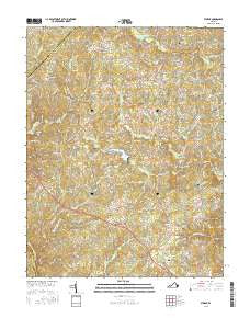
~ Storck VA topo map, 1:24000 scale, 7.5 X 7.5 Minute, 2016
Storck, Virginia, USGS topographic map dated 2016.
Includes geographic coordinates (latitude and longitude). This topographic map is suitable for hiking, camping, and exploring, or framing it as a wall map.
Printed on-demand using high resolution imagery, on heavy weight and acid free paper, or alternatively on a variety of synthetic materials.
Topos available on paper, Waterproof, Poly, or Tyvek. Usually shipping rolled, unless combined with other folded maps in one order.
- Product Number: USGS-8264462
- Free digital map download (high-resolution, GeoPDF): Storck, Virginia (file size: 27 MB)
- Map Size: please refer to the dimensions of the GeoPDF map above
- Weight (paper map): ca. 55 grams
- Map Type: POD USGS Topographic Map
- Map Series: US Topo
- Map Verison: Current
- Cell ID: 43357
- Datum: North American Datum of 1983
- Map Projection: Transverse Mercator
- Map Cell Name: Storck
- Grid size: 7.5 X 7.5 Minute
- Date on map: 2016
- Map Scale: 1:24000
- Geographical region: Virginia, United States
Neighboring Maps:
All neighboring USGS topo maps are available for sale online at a variety of scales.
Spatial coverage:
Topo map Storck, Virginia, covers the geographical area associated the following places:
- Cedar Knolls Estates - Majestic Ridge Estates - Rosedale - Keatwood - Red Hill - Seven Lakes - Roseville Heights - Rappahannock Ridge Estates - Cypress Estates - Sherwood Forest - Chesterfield - Brandy Hills - Concord Estates - The Estates - Parkside - Deep Run - The Blake Farm - Cool River - Cannon Knolls - Stefaniga - Timberidge - Kings Grant - Glendie - Roseville - Skyline Hills - Rose Hill Farms - Seymour Knolls - Dodds Corner - Mansefield - Lakeland Forest - Stonehouse Wooded Estates - Hunters Pond - Royal Hills Estates - Willowmere - Whitestone - Tacketts Farm - Crestwood - Walden Ten - Hoys Way - Shackelford Estates - Stefaniga Road - Roseville Plantation - Hartlake Estates - Davis Corner - Hartwood Meadows - Hartwood - Water Edge Estates - The Willows - Stony Hill Estates - Harwill Acres - Hampshire Forest - Hartwood Manor - Nellie Estates - Norwood Hills - Cropp Road Estates - Storck Run - Ivyglen - Chesterwood - Concord - Diamond Park - Manor Wood Estates - Cropp - Heflin - Winslow Heights - Eagles Nest - Marsh Run Estates - Windsor Forest - Milburn Estates - Crown Manor - Long Branch - The Preserve on Aquia Creek - Beverly Estates - Georgetown West - Christy Farm - Hartwood Village - Gauntlet Estates - Country Wood Estates - Valhalla - Paynes Corner - Richland Forest - Rosewood Estates - Barrington Woods - Carrera Estates - The Cascades - Laurelwood - Ashburn Hills - Amsonia - Skidmore Corner - Storck
- Map Area ID: AREA38.538.375-77.625-77.5
- Northwest corner Lat/Long code: USGSNW38.5-77.625
- Northeast corner Lat/Long code: USGSNE38.5-77.5
- Southwest corner Lat/Long code: USGSSW38.375-77.625
- Southeast corner Lat/Long code: USGSSE38.375-77.5
- Northern map edge Latitude: 38.5
- Southern map edge Latitude: 38.375
- Western map edge Longitude: -77.625
- Eastern map edge Longitude: -77.5


