
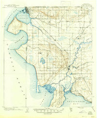
~ Blaine WA topo map, 1:62500 scale, 15 X 15 Minute, Historical, 1907, updated 1947
Blaine, Washington, USGS topographic map dated 1907.
Includes geographic coordinates (latitude and longitude). This topographic map is suitable for hiking, camping, and exploring, or framing it as a wall map.
Printed on-demand using high resolution imagery, on heavy weight and acid free paper, or alternatively on a variety of synthetic materials.
Topos available on paper, Waterproof, Poly, or Tyvek. Usually shipping rolled, unless combined with other folded maps in one order.
- Product Number: USGS-5686965
- Free digital map download (high-resolution, GeoPDF): Blaine, Washington (file size: 9 MB)
- Map Size: please refer to the dimensions of the GeoPDF map above
- Weight (paper map): ca. 55 grams
- Map Type: POD USGS Topographic Map
- Map Series: HTMC
- Map Verison: Historical
- Cell ID: 51495
- Scan ID: 240095
- Imprint Year: 1947
- Survey Year: 1905
- Datum: Unstated
- Map Projection: Polyconic
- Map published by United States Geological Survey
- Keywords: Overedge with No Adjacent Map
- Map Language: English
- Scanner Resolution: 600 dpi
- Map Cell Name: Blaine
- Grid size: 15 X 15 Minute
- Date on map: 1907
- Map Scale: 1:62500
- Geographical region: Washington, United States
Neighboring Maps:
All neighboring USGS topo maps are available for sale online at a variety of scales.
Spatial coverage:
Topo map Blaine, Washington, covers the geographical area associated the following places:
- Ferndale - Kickerville - Lummi - Portal Way Mobile Village - Birchwood - Northwest Mobile Home Park - Manthey's Country Mobile Home Park - Edgewater Resort and Trailer Park - Evergreen Mobile Home Park - Marietta - Neptune Beach - Mountain View Estates Mobile Home Park - Alderwood - Baywood Mobile Home Park - Mountain Vista Mobile Home Park - Pleasant Valley - Birch Bay Resort Mobile Home Park - Birch Bay - Duncans Mobile Home Park - Birch Bay Circle Grange - Ferndale Mobile Village - Portal Creek Mobile Home Park - Blaine - Bel Air Village Trailer Court - Custer - Mountain View - Brennan - Barrett Lake Mobile Home Park - Delta - Haynie - Lamplighter Mobile Park - Fairfield Mobile Home Park - Larsen Mobile Manor - Plaza Mobile Home Park - Hillsdale
- Map Area ID: AREA4948.75-122.75-122.5
- Northwest corner Lat/Long code: USGSNW49-122.75
- Northeast corner Lat/Long code: USGSNE49-122.5
- Southwest corner Lat/Long code: USGSSW48.75-122.75
- Southeast corner Lat/Long code: USGSSE48.75-122.5
- Northern map edge Latitude: 49
- Southern map edge Latitude: 48.75
- Western map edge Longitude: -122.75
- Eastern map edge Longitude: -122.5


