
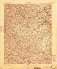
~ Raleigh WV topo map, 1:125000 scale, 30 X 30 Minute, Historical, 1902, updated 1905
Raleigh, West Virginia, USGS topographic map dated 1902.
Includes geographic coordinates (latitude and longitude). This topographic map is suitable for hiking, camping, and exploring, or framing it as a wall map.
Printed on-demand using high resolution imagery, on heavy weight and acid free paper, or alternatively on a variety of synthetic materials.
Topos available on paper, Waterproof, Poly, or Tyvek. Usually shipping rolled, unless combined with other folded maps in one order.
- Product Number: USGS-5638761
- Free digital map download (high-resolution, GeoPDF): Raleigh, West Virginia (file size: 13 MB)
- Map Size: please refer to the dimensions of the GeoPDF map above
- Weight (paper map): ca. 55 grams
- Map Type: POD USGS Topographic Map
- Map Series: HTMC
- Map Verison: Historical
- Cell ID: 395869
- Scan ID: 254009
- Imprint Year: 1905
- Survey Year: 1895
- Datum: Unstated
- Map Projection: Unstated
- Map published by United States Geological Survey
- Map Language: English
- Scanner Resolution: 600 dpi
- Map Cell Name: Raleigh
- Grid size: 30 X 30 Minute
- Date on map: 1902
- Map Scale: 1:125000
- Geographical region: West Virginia, United States
Neighboring Maps:
All neighboring USGS topo maps are available for sale online at a variety of scales.
Spatial coverage:
Topo map Raleigh, West Virginia, covers the geographical area associated the following places:
- Glade - Saulsville - Dry Hill - Posey - McCreery - Dothan - Crow - Matville - Oak Hill - Lanark - Josephine - Wickham - Lego - Wingrove - Stotesbury - Itmann - Newlyn - Arnett - Kilsyth - Sanger - Hoohoo - Mount Tabor - Dewitt - Norvell (historical) - Hilltop - Piney View - Riley - Westerly - Thurmond - MacArthur - James Crest Farms - Wright - Oswald (historical) - Fire Creek (historical) - Glen Morgan - Egeria - Salem - Cool Ridge - Pemberton - Odd - Killarney - Roseville (historical) - East Sewell (historical) - McVey - Battleship - Milburn - Dorothy - Cranberry - Terry - Circle View - Oak Hill Junction - Baylor (historical) - Sylvia (historical) - Mount Hope - Maple Meadow - Winding Gulf - East Oak Hill - White Stick (historical) - Kingston - Ravencliff - Raleigh - Ghent - Princewick - Flat Top - Wyco - Lillybrook - Take In Hollow - Lynwinn - Eastgulf - Mabscott - Newfound - Skelton - Glen White - United - Hotchkiss - Claremont - Beaver - Ameagle - Fitzpatrick - Herndon Heights - Export (historical) - Glen View - Warden - McGraws - Blue Jay 6 - Prince - Mead - Eccles - Besoco - Jonben - McKendree - Montecarlo - Jenny Gap (historical) - Whipple Junction - Concho - Bud - Quinnimont - Elmore - Slab Fork - Lester
- Map Area ID: AREA3837.5-81.5-81
- Northwest corner Lat/Long code: USGSNW38-81.5
- Northeast corner Lat/Long code: USGSNE38-81
- Southwest corner Lat/Long code: USGSSW37.5-81.5
- Southeast corner Lat/Long code: USGSSE37.5-81
- Northern map edge Latitude: 38
- Southern map edge Latitude: 37.5
- Western map edge Longitude: -81.5
- Eastern map edge Longitude: -81


