
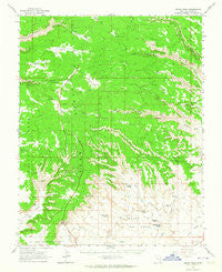
~ Cedar Mesa UT topo map, 1:62500 scale, 15 X 15 Minute, Historical, 1963, updated 1964
Cedar Mesa, Utah, USGS topographic map dated 1963.
Includes geographic coordinates (latitude and longitude). This topographic map is suitable for hiking, camping, and exploring, or framing it as a wall map.
Printed on-demand using high resolution imagery, on heavy weight and acid free paper, or alternatively on a variety of synthetic materials.
Topos available on paper, Waterproof, Poly, or Tyvek. Usually shipping rolled, unless combined with other folded maps in one order.
- Product Number: USGS-5462313
- Free digital map download (high-resolution, GeoPDF): Cedar Mesa, Utah (file size: 7 MB)
- Map Size: please refer to the dimensions of the GeoPDF map above
- Weight (paper map): ca. 55 grams
- Map Type: POD USGS Topographic Map
- Map Series: HTMC
- Map Verison: Historical
- Cell ID: 52305
- Scan ID: 248545
- Imprint Year: 1964
- Woodland Tint: Yes
- Aerial Photo Year: 1959
- Field Check Year: 1963
- Datum: NAD27
- Map Projection: Polyconic
- Map published by United States Geological Survey
- Map Language: English
- Scanner Resolution: 600 dpi
- Map Cell Name: Cedar Mesa
- Grid size: 15 X 15 Minute
- Date on map: 1963
- Map Scale: 1:62500
- Geographical region: Utah, United States
Neighboring Maps:
All neighboring USGS topo maps are available for sale online at a variety of scales.
Spatial coverage:
Topo map Cedar Mesa, Utah, covers the geographical area associated the following places:
- Moki Dugway Overlook - Long Flat - Bullet Canyon Trailhead - Prehistoric Cave Spring Number Two (historical) - Coyote Flat - Cedar Mesa - Watershed Study Plot - Battleship Rock - Castle Butte - Moki Dugway - Lady in the Bathtub - Franklin Butte - Lion Tracks Spring - Moki Dugway - Pyramid Peak - Setting Hen Butte - Sheiks Flat - Rooster Butte - Todie Spring - Lees Ranch - Brushy Flat - Split Level Ruin - Todie Flat - Cigarette Spring - Nevills Arch - Emigrant Trail - Todie Canyon - Snow Flat - Valley of the Gods
- Map Area ID: AREA37.537.25-110-109.75
- Northwest corner Lat/Long code: USGSNW37.5-110
- Northeast corner Lat/Long code: USGSNE37.5-109.75
- Southwest corner Lat/Long code: USGSSW37.25-110
- Southeast corner Lat/Long code: USGSSE37.25-109.75
- Northern map edge Latitude: 37.5
- Southern map edge Latitude: 37.25
- Western map edge Longitude: -110
- Eastern map edge Longitude: -109.75


