
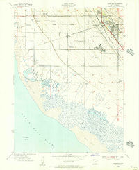
~ Clearfield UT topo map, 1:24000 scale, 7.5 X 7.5 Minute, Historical, 1955, updated 1956
Clearfield, Utah, USGS topographic map dated 1955.
Includes geographic coordinates (latitude and longitude). This topographic map is suitable for hiking, camping, and exploring, or framing it as a wall map.
Printed on-demand using high resolution imagery, on heavy weight and acid free paper, or alternatively on a variety of synthetic materials.
Topos available on paper, Waterproof, Poly, or Tyvek. Usually shipping rolled, unless combined with other folded maps in one order.
- Product Number: USGS-5456411
- Free digital map download (high-resolution, GeoPDF): Clearfield, Utah (file size: 9 MB)
- Map Size: please refer to the dimensions of the GeoPDF map above
- Weight (paper map): ca. 55 grams
- Map Type: POD USGS Topographic Map
- Map Series: HTMC
- Map Verison: Historical
- Cell ID: 9073
- Scan ID: 248655
- Imprint Year: 1956
- Woodland Tint: Yes
- Aerial Photo Year: 1954
- Field Check Year: 1955
- Survey Year: 1926
- Datum: NAD27
- Map Projection: Polyconic
- Map published by United States Geological Survey
- Map published by United States Army Corps of Engineers
- Map Language: English
- Scanner Resolution: 600 dpi
- Map Cell Name: Clearfield
- Grid size: 7.5 X 7.5 Minute
- Date on map: 1955
- Map Scale: 1:24000
- Geographical region: Utah, United States
Neighboring Maps:
All neighboring USGS topo maps are available for sale online at a variety of scales.
Spatial coverage:
Topo map Clearfield, Utah, covers the geographical area associated the following places:
- Steed - Thornleys - Green Pastures - Country Village - Grants Lane - Syracuse - Stuart - Westwood Estates - Bridgewood Manor Condominium - Barlow Heights - Lakeview Condominium - Valley West Ranches - Lou-vre Estates - Westland - Shimada Acres - Clearfield Villa - Equestrian Ranchettes - Jamarl Acres - Layton Park - Smith Village - Villa Vista - Kristalyn Gardens - Smedley Acres - Clearfield Terrace - Ranchettes West - Pratts - Airlane Park - Sky West Estates - Clearfield - Valhalla Estates - Westmond Condominium - Vae View - West Gate Addition - Suntrails - Clearfield Estates - Oakcrest Estates - Country Crossing - Cherry Hill - Park West Estates - Edgehill Estates - Marilyn Acres - Thurgood Estates - Golden Park - Barnes - Al Vita Park - Lori Estates - West Point - Katies Place - Glade Nielsen - Lakeview - Rhoades Lane - Meadow Park - Grandview Acres - Valley View - Bluff Road - Yorkshire Place - Sundial Park - Allison Acres - Anchorage - Clearfield Heights - Brimhall Estates - Green Hill Acres - Melanie Acres - Campbell Heights - Terrace View - Smith Estates - Bel-Aire Condominium - Frew Estates - Southwood - Henry Oleson - Julie Estates - Newport Haven - West Sunset View Estates - Central Park Addition
- Map Area ID: AREA41.12541-112.125-112
- Northwest corner Lat/Long code: USGSNW41.125-112.125
- Northeast corner Lat/Long code: USGSNE41.125-112
- Southwest corner Lat/Long code: USGSSW41-112.125
- Southeast corner Lat/Long code: USGSSE41-112
- Northern map edge Latitude: 41.125
- Southern map edge Latitude: 41
- Western map edge Longitude: -112.125
- Eastern map edge Longitude: -112


